Plan Framework
Mobility
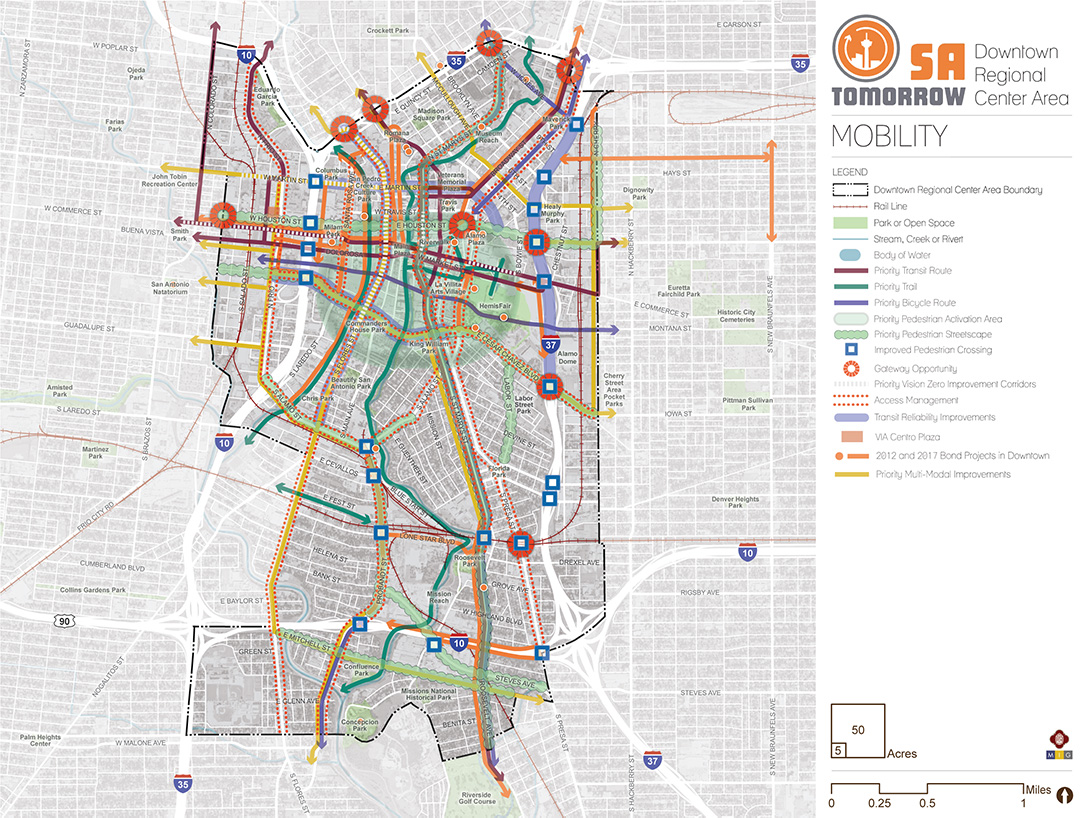
The map below highlights the Mobility Framework identified for the Downtown Regional Center Area. Scroll down to learn more about the vision for Mobility in the Plan Area.
To provide specific feedback on the map, please click and drag a box on that location of the map and fill out the comment box.

Background and Vision
In 2016, the City of San Antonio adopted the SA Tomorrow Multimodal Transportation Plan, to make our city’s transportation system “sustainable, safe, convenient, efficient, and inclusive of all modes.” The plan adopted by City Council established “a shift in focus from moving vehicles to moving people,” in order to manage traffic congestion, and improve transportation choices. The plan identified two primary and interdependent methods for managing future traffic congestion:
- Develop a land use pattern and policy to promote local trips
- Provide transportation options, in addition to automobiles, that connect Regional Centers
The SA Tomorrow Multimodal Transportation Plan acknowledged that we cannot build our way out of congestion and that the Comprehensive Plan ‒ and associated land use plans ‒ are a primary opportunity to improve mobility in San Antonio. By welcoming more people to live, work and play in urban centers, regional centers, and transit corridors, we can shorten trip lengths, offer more transportation choices, and improve quality of life.
The combined costs of housing and transportation (commonly referred to as H+T) are often a large portion of a household’s budget, with experts recommending the combined total not be more than 45% of household income. In the Greater San Antonio region that total, on average, is 53%. Walkable communities that provide great transit options can reduce the household transportation costs for the average person because if people have an alternative to driving alone, transportation costs can be stable even when gas prices rise. By providing transportation options, as some people choose to go to their destination on foot, bicycle or transit, the number of cars on the road will be minimized, reducing traffic delay for those people that choose to drive.
As San Antonio’s hub of business, government, entertainment, and culture the Downtown Area Regional Center plays a central role in the growth and health of the region. The Downtown Area anchors San Antonio’s thriving tourism industry, as well as other major employment sectors, such as governmental agencies, healthcare, and finance. Downtown is home to some of the most walkable and bikeable areas of the city, and serves as the heart of the regional transit system. Nevertheless, more investments in multimodal infrastructure are needed to keep this area mobile, as well as connect the region to its historic, economic, and cultural center.
The mobility vision for Downtown focuses on creating a vibrant and diverse urban center, welcoming residents, workers, and visitors alike. With an abundance of historic and contemporary public spaces and urban greenways, downtown is connected and livable. Transit, safe bicycle and pedestrian infrastructure, and micromobility options provide convenient choices for getting around. These options allow people to access destinations near their homes without having to drive. A number of trails provide separated facilities for people walking, bicycling, or strolling, including the San Pedro Creek Cultural Park and the San Antonio River Walk (including the Museum Reachand Mission Reach). These trails provide a low-stress pathway for commuting, but also connect residents and visitors to San Antonio’s extraordinary cultural and natural heritage. The Westside Creeks of the Howard W. Peak Greenway Trails system, stemming from Alazan and Apache Creeks, provide Downtown connections to Westside destinations like Our Lady of the Lake University and Woodlawn Lake Park.
As high-capacity transit options mature and evolve, Downtown will remain the nexus of the region’s most frequent service. Primo service will be joined by north-south and east-west Rapid Transit Corridors and other frequent routes, including express service to outlying regional centers (such as the Brooks Area, Medical Center Area and Stone Oak Area Regional Centers). Sidewalks, streetscaping, and complete streets will also support transit usage to and from Downtown. Pedestrians will have a range of last mile connections between transit stations and their downtown destinations, including safe environments for walking, people riding bicycles, micromobility options (e.g. scooters), or shared mobility options (e.g. rideshare or Transportation Networking Companies).
Downtown Regional Center’s Mobility Needs
The Downtown Area Regional Center is the region’s economic and cultural center. A mobile downtown will continue to spur sustainable growth in the Greater San Antonio Region. As this growth continues, the City of San Antonio, VIA and the Texas Department of Transportation must implement solutions that ensure access, livability, and vitality downtown. Key mobility needs include the following:
- Safety of the transportation network, for all users, but especially pedestrians and bicyclists;
- Multimodal improvements - transformation of the transportation network to serve people choosing to walk, bicycle, scooter, take transit, rideshare, or travel in their own vehicle
- Better connections between the Downtown Area with all other Regional Centers in the broader San Antonio area;
- Improved curb management and parking strategies to accommodate shared and micromobility options, and allocation of additional space for multimodal improvements; and
- Improved connections to the neighborhoods adjacent to the Downtown Area.
A set of high-level recommendations have been developed to address these Downtown Area Regional Center mobility needs, along with a set of strategies to implement the recommendations through projects, policies, and partnerships. These recommendations and strategies are also illustrated on the Mobility Recommendations map.
Recommendation #1:
Continue Implementing the San Antonio Vision Zero Action Plan.
The City of San Antonio’s Vision Zero initiative aims to achieve zero fatalities on the community’s roadways and improve roadway safety for all users, whether driving, bicycling, or walking. The Vision Zero initiative evaluates and makes recommendations to improve safety in Severe Pedestrian Injury Areas (SPIAs), locations where two or more crashes close together have resulted in severe pedestrian injuries. Potential tools for improving pedestrian safety in Severe Pedestrian Injury Areas include leading pedestrian intervals, medians, pedestrian crossing islands, intersection crossing markings, curb extensions, and even widening sidewalks based upon analysis of the unique factors that contribute to crashes in each location and depending upon the results of engineering assessments. Improvements in pedestrian amenities, including safe lighting and landscaping, can also make these areas more inviting and visible. Another approach to improve safety involves dedicating more space in the roadway to bicyclists and pedestrians. From new ways to protect bicycle lanes with separated barriers such as bollards, to landscaping and planters and raised medians, San Antonio has many available tools to improve pedestrian and bicycle safety. The City of San Antonio Vision Zero Action Plan lists additional tools for improving pedestrian and bicycle safety.
The Downtown Area Regional Center has a wealth of opportunities for improving transportation and safety. Transportation investments that focus on safety, such as improving crossings and investing in complete streets can have a significant positive impact throughout the Downtown Area Regional Center. In particular, the 2017 San Antonio Severe Pedestrian Injury Areas Report (pages 25-26) identifies six Severe Pedestrian Injury Areas (SPIAs) within or adjacent to the Downtown Area Regional Center that should be priorities for study and investment:
- Flores Street from Euclid Avenue to El Paso Street;
- Martin Street from Comal Street to Flores Street;
- Commerce Street from Alamo Plaza to Bowie Street;
- Commerce Street from Smith Street to Santa Rosa Street;
- St Mary’s Street from Commerce Street to Travis Street; and
- Market Street from St. Mary’s Street to Alamo Street;
Additional analysis of pedestrian, bicycle, and vehicle crash data, along with community input, also identified additional points of conflict between people and vehicles that should be studied for future improvements. Major highways, such as IH-10, IH-35, and IH-37, and their associated frontage roads, create barriers for many pedestrians and bicyclists. The unwelcoming environment of fast speeds and incomplete networks limits travel options for those walking or bicycling. Major roadways, like St. Mary’s Street,Broadway, Cesar Chavez Boulevard, and Alamo Street have insufficient accommodations and less than ideal conditions for pedestrians and bicycles to travel on and cross safely. In addition, numerous driveways and some valet stands create many potential conflict points between automobiles, pedestrians, and bicycles. Employing strategies to reduce and prevent these points of conflict can increase safety in the study area.
Investments that focus on safety, such as the Vision Zero tools listed above, can have a significant positive impact on Downtown, and especially in these identified conflict areas. Reducing speeds in appropriate areas can also greatly improve safety for all users by reducing the likelihood and intensity of crashes.
Recommendation #2:
Focus Downtown Mobility Resources to Support San Antonio’s Multimodal Transportation Network.Multimodal and connected networks are key aspects to providing mobility for all users, regardless of ability or financial status. Transit improvements ensure areas are accessible while bicycle and pedestrian infrastructure provide last-mile connections to and from transit and key destinations. Urban design elements such as driveway relocation, street calming, and complete streets further support these improvements while providing safe and inviting spaces.
Shifting users from driving alone to alternative modes of transportation can alleviate congestion along a corridor or within an area. This becomes more viable when alternatives are convenient, such as through improved access to transit and pedestrian-friendly infrastructure. This strategy directly supports the community's, City’s, and VIA’s goals and objectives, improving access to key destinations, decreasing vehicle miles traveled, and increasing walkability. To support growth and continue the vibrancy of the region’s economic centers, the community needs easy, comfortable, reliable, and congestion-proof choices for traveling to and from work, school, and key destinations.
Priority Streetscape Improvements
Streetscape improvements such as trees, decorative street lighting, benches, or other place identifiers can enhance the unique qualities of a place and make walking and exploring more enjoyable. The vision for these corridors is one where people walking, biking, or taking transit or rideshare brings street-level activity to create safer and more vibrant streets.
Such improvements are envisioned on the following roadways that are not part of the 2012 or 2017 Capital Improvements Bond Programs:
- McCullough Avenue from IH-35 to St. Mary’s Street;
- McCullough Avenue and Nolan Street from Bonham Street to Cherry Street;
- San Pedro Avenue from IH-35 to Main Avenue;
- Flores Street from IH-35 to Martin Street;
- Martin Street from IH-35 to Flores Street;
- Frio Street from Martin Street to Commerce Street;
- Frio Street from Cesar Chavez Boulevard to Guadalupe Street;
- Cherry Street from Commerce Street to Iowa Street;
- Labor Street from Cesar Chavez Boulevard to Presa Street;
- Flores Street from Guadalupe Street to Cevallos Street;
- Cevallos Street from Flores Street to Probandt Street;
- Alamo Street from Flores Street to Probandt Street; and
- Steves Avenue from Probandt Street to Roosevelt Avenue.
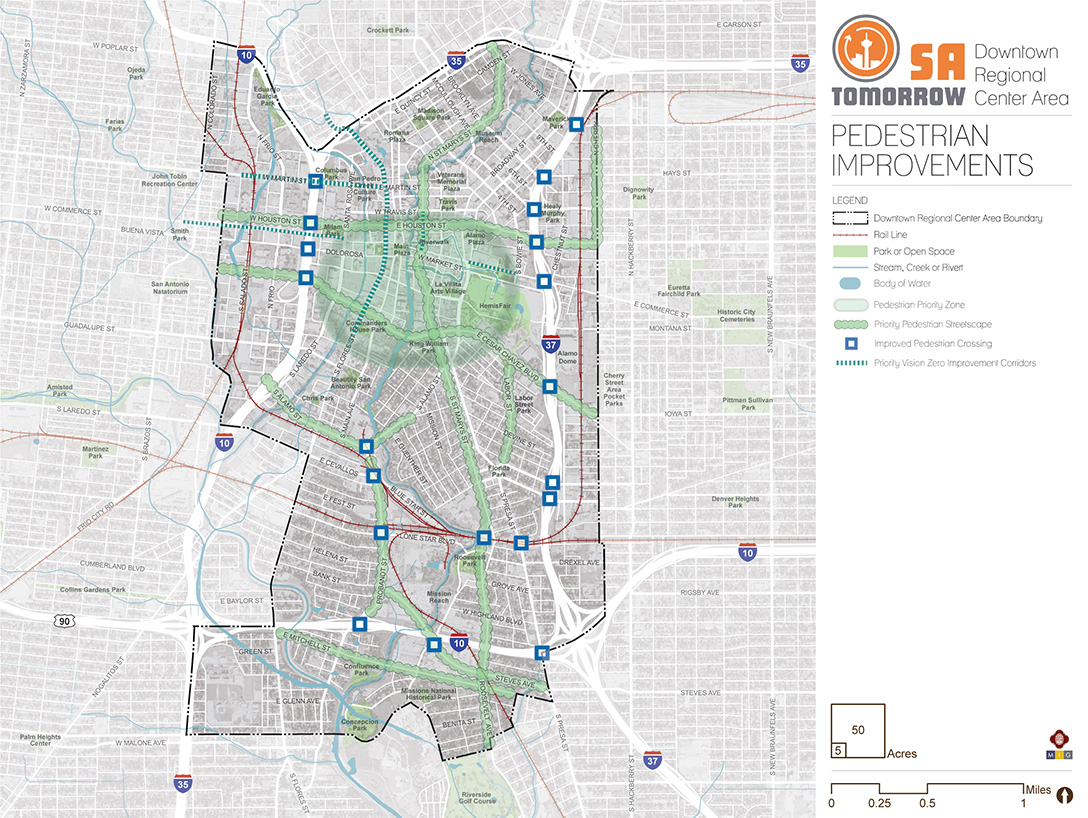
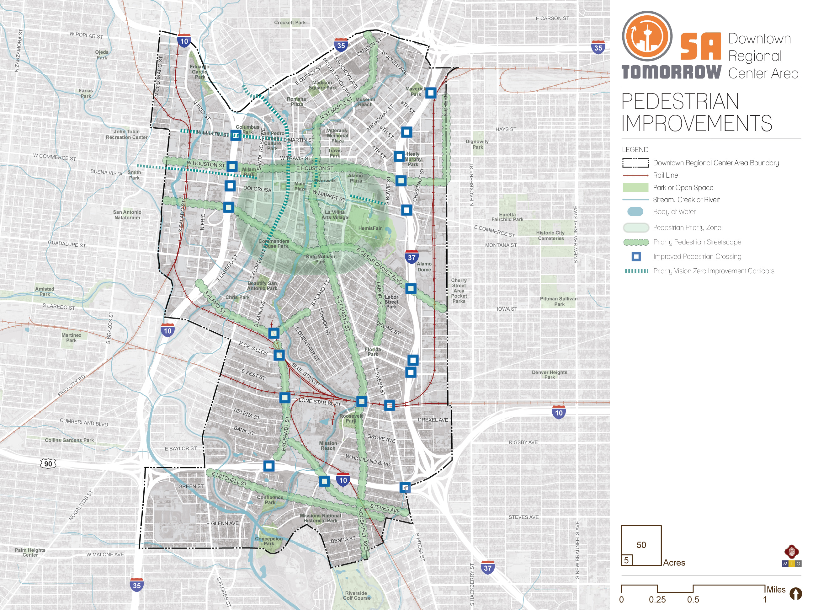
Downtown Pedestrian Priority Zone
In a vibrant downtown, automobile level of service is of less importance than safely and comfortably moving people walking, riding bicycles, and using other modes of transportation. The area within the core of the Downtown Area Regional Center Plan has the highest concentration of activity in the area but is also the most constrained in terms of physical space available to provide streets and sidewalks. In light of this, the Downtown core should be a pedestrian-oriented space that prioritizes the movement of people walking, riding bicycles, and using transit over the movement of people driving cars. Street design and signal timing should support slower vehicle speeds and prioritize pedestrians. Driveways should be consolidated and/or relocated to minimize the number of curb cuts and potential points of conflict between pedestrians and vehicles. Streetscape improvements such as trees and landscaping, wide sidewalks, decorative street lighting, benches and other furnishings should be provided to enhance the pedestrian realm and make downtown sidewalks more comfortable and inviting places to spend time.
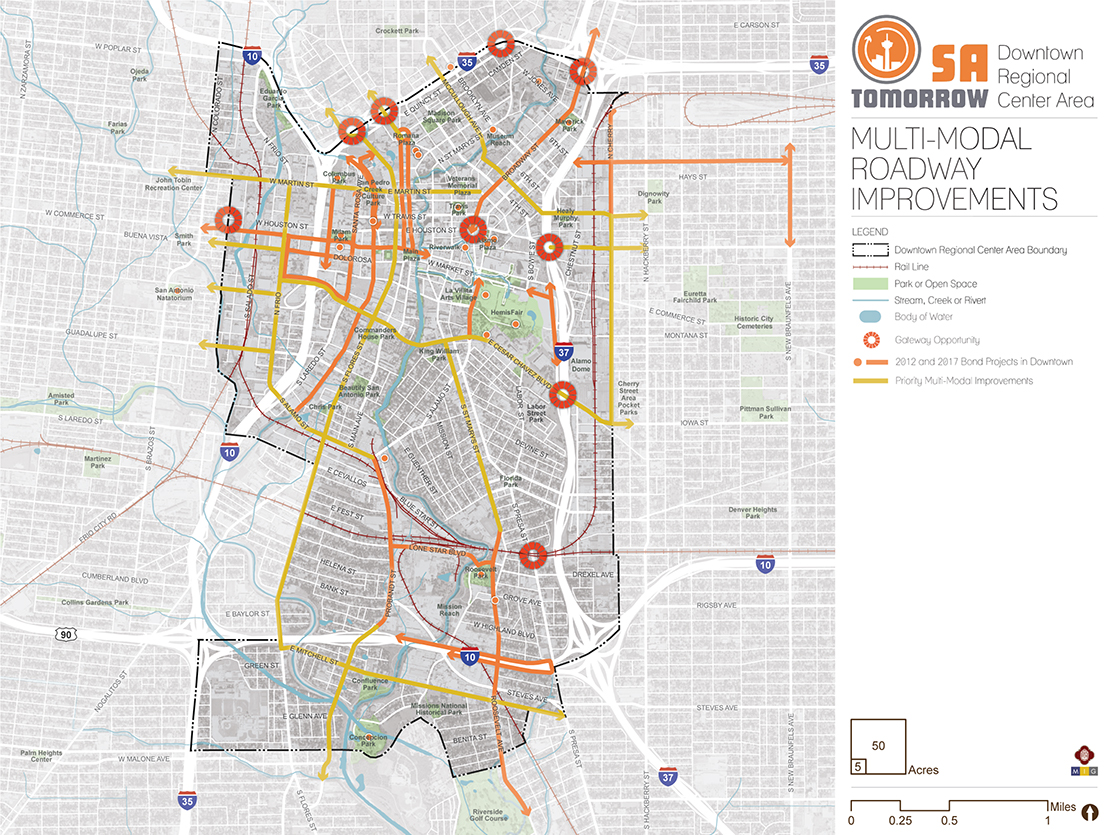
Priority Multimodal Improvements
Bicyclists currently endure unsafe conditions like riding directly adjacent to vehicle traffic along busy roads. Additional bike infrastructure, such as designated lanes, is needed for safer streets. These measures will improve riding conditions for today’s commuters and welcome newer, less confident bicyclists, otherwise unaccustomed to riding alongside vehicles.
Within the Downtown Area Regional Center every street should ideally provide spaces accessible for vehicles, pedestrians, and cyclists alike, a concept known as “Complete Streets.” However, the space available to reconstruct streets in the Downtown Area is constrained due to historically narrow right-of-way and many buildings built on or near property lines, setting them very close to the street. Such limitations necessitate careful consideration of how each street segment functions and which modes should be prioritized and can safely coexist in the same right-of-way. To ensure we make the greatest impact on mobility of all street users in the Downtown Area this plan must prioritize street segments for improvements. Streets were prioritized based on their location relative to a focus area, connection to Downtown adjacent neighborhoods, and significance to connectivity within the Downtown Area Regional Center Plan. The following are recommended for priority multimodal street improvements:
- St. Mary’s Street (from Cesar Chavez Boulevard to Roosevelt Avenue);
- San Pedro Avenue (from IH-35 to Main Avenue);
- Martin Street (from Colorado Street to Broadway Street);
- Houston Street (from IH-37 to Cherry Street); Frio Street (from Cesar Chavez Boulevard to Alamo Street);
- Cherry Street (from Dawson Street to Iowa Street);
- Probandt Street (from IH-10/ US Hwy 90 to West Theo Avenue);
- Mitchell Street (from Flores Street to Presa Street);
- Alamo Street (from Frio Street to Probandt Street);
- Flores Street (from IH-35 to Mitchell Street);
- McCullough Avenue (from IH-35 to IH-37);
- Nolan Street (from IH-37 to Cherry Street);
- Guadalupe Street (from Flores Street to Alazan Creek); and
- Cesar Chavez Boulevard (from Santa Rosa Street to Cherry Street).
These streets will also connect to recreational trails and parks, such as the existing Howard W. Peak Greenway Trails and San Antonio River Walk Trails, and the nearby Mission Reach, which connects four 18th century Spanish missions.
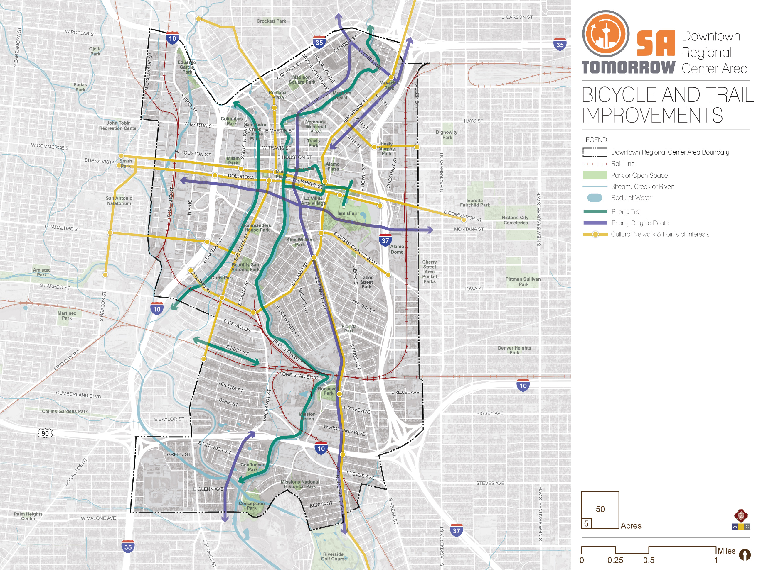
Priority Trails
Key trails nearby or within the Downtown Area Regional Center, like San Pedro Creek Cultural Park, the San Antonio River Walk (including the Museum Reach, and Mission Reach), and the Alazan and Apache Creeks Greenway Trails provide critical continuous arteries of separated pedestrian and bicycling infrastructure, connecting numerous parks, retail locations, schools, and libraries. The critical access points to these regional amenities provide opportunities to improve connections for people walking, strolling or bicycling with deliberate side paths or on-road infrastructure like crosswalks, sidewalks and bicycle facilities.
Preferred Bicycle Routes
Bicyclists currently endure unsafe conditions like riding in mixed-traffic on high-speed and high-volume roads. Additional bike infrastructure, such as protected and separated lanes, is needed for safer streets. These measures will improve riding conditions for today’s commuters and welcome newer, less confident bicyclists, otherwise unaccustomed to riding alongside vehicles. The provision of bicycle parking and bike share at transit provides an important connection for people wanting to access transit by bicycle and helps to address the ‘last mile’ challenge, helping people connect from their destinations to and from transit.
Based on input from the Downtown Area Planning Team and other community stakeholders, the plan identifies priority bicycle routes including:
- Navarro Street/St. Mary’s Street/Roosevelt Avenue (from IH-35 to Hansford Street);
- Jones Avenue (from IH-35 to IH-37);
- Alamo Street (from IH-35 to Houston Street);
- Nueva Street/Montana Street (from South Pecos La Trinidad Street to Cherry Street, through Hemisfair Park); and
- Probandt Street (from IH-10 to Theo Avenue).
Corridors identified for complete streets should also incorporate cycling infrastructure as a component of the design based on future studies by the Transportation and Capital Improvements (TCI) Department to determine feasibility and the types of facilities needed.
Recommendation #3:
Create New Connections Between Downtown And the near Westside By Mitigating Physical And Psychological Barriers.
Both Alazan Creek and the railroad tracks are physical barriers between Downtown and the near westside, limiting connectivity for all modes of travel to a few crossing points. Psychological barriers, such as real and perceived unsafe conditions, dilapidated and vacant buildings, and lack of pedestrian-oriented streetscapes exacerbate the poor physical connectivity.
A new physical connection should be created by extending Cesar Chavez Boulevard beyond its current terminus at Frio Street, traversing the railroad tracks by under-pass, over-pass, or grade crossing, and bridging Alazan Creek to link with West Cesar Chavez Boulevard. This new connection should include facilities for pedestrians, bicycles, and vehicles and should not displace Tafolla Middle School.
Psychological barriers should be addressed through improvements to streetscapes to prioritize the experience of pedestrians and people riding bicycles. In particular, the Guadalupe Street Bridge should incorporate expanded sidewalks, pedestrian lighting, and bike facilities.
Recommendation #5:
Manage Transportation Demand through Deliberate Parking Management Strategies and Traffic Management Plans that Prioritize Pedestrian, Bicycle, and Transit Options during Congestion, Special Events and Construction.![]()
Downtown San Antonio is host to countless special events and critical construction projects that place heightened strain the street network and creates challenges for people using alternative modes of transportation. This additional congestion requires strategies that encourage multimodal choices and allow one-time or infrequent visitors to navigate transportation options and Downtown parking areas more efficiently.
Parking and Construction Mitigation
Parking management solutions integrating both privately- and publically-operated facilities provide information on parking availability at key locations, as well as traffic conditions, and utilize guide signs help visitors find their way to desired parking areas. These same strategies can also be used to effectively direct vehicles through construction-related congestion. Pricing strategies also generate revenue for parking spaces based on demand and incentivize alternative transportation if cost becomes a barrier to parking. Identification of safe and convenient alternative paths for pedestrians, cyclists, and micromobility riders integrated into construction traffic plans is also critical.
Peak Congestion
While congestion can be viewed as a sign of economic health, delays caused by congestion waste valuable time and create transportation emissions that reduce air quality. A series of targeted operational and multimodal interventions can provide more travel options and reduce the demand on our roadways. Key investments to reduce congestion and conflict zones that delay transit can help transit stay on schedule and move more rapidly on San Antonio’s roadways. These improvements, such as peak hour or school zone bus only lanes, queue jump traffic signals, and grade separated railroad tracks, paired with other VIA Metropolitan Transit investments in service, can help make transit a more attractive travel option. This recommendation is responsive to the community goal to “Connect Districts and Neighborhoods with an Accessible Multimodal Network” and the SA Tomorrow Multimodal Plan’s goal of multimodal transportation. These strategies can support the vibrancy of the region’s economic centers, by connecting residents with easy, reliable, and congestion‑proof choices to and from work, school, and key destinations.
Special Events
The Henry B. Gonzalez Convention Center, The Tobin Center for the Performing Arts, Alamodome & Sunset Station, and Hemisfair Park each generate sufficient congestion to mandate special events traffic plan strategies. Key improvements could improve the experience for those using transit, shared mobility and micromobility during special events, including special event priority lanes to give priority to buses during the traffic surges of planned events or bus bulbs to allow buses to pick up passengers without exiting and re-entering traffic. Specific plans to facilitate ease of use of shared mobility options and micromobility will help relieve stress on the transportation network during special events. Studies will need to be conducted to determine the appropriateness for each strategy for the areas of local congestion.
Recommendation #6:
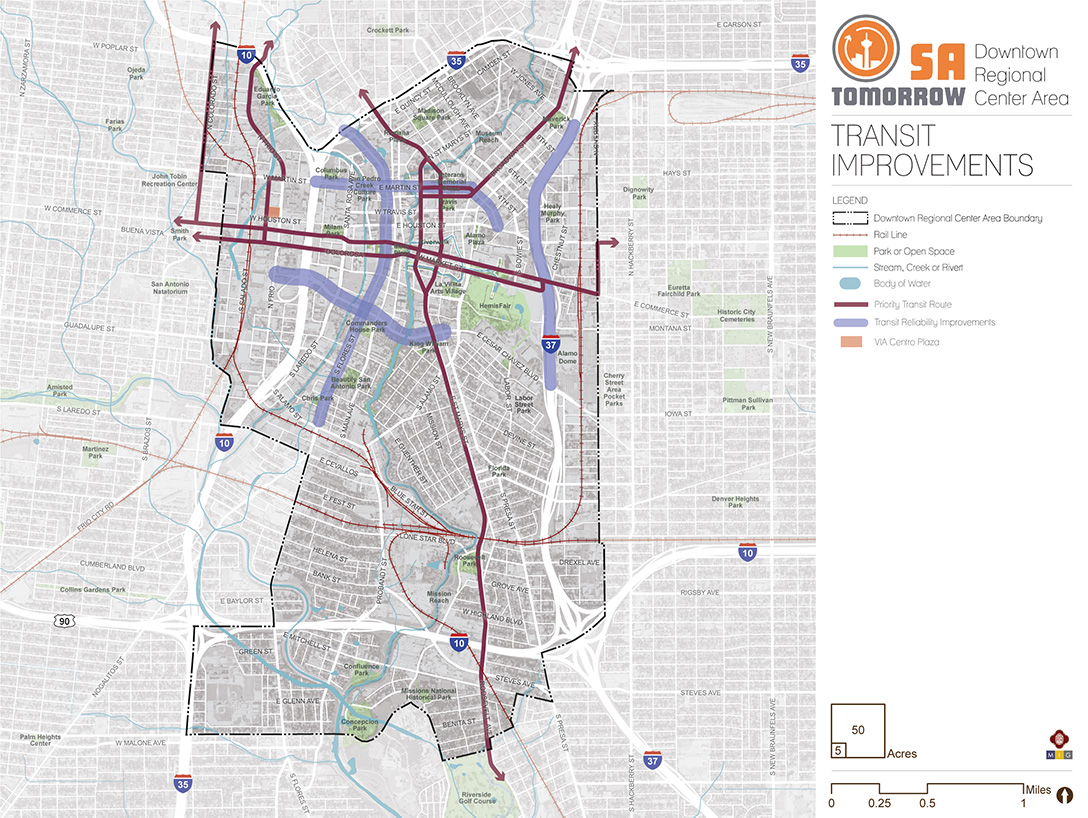
Support Proposed VIA Metropolitan Transit Rapid Transit Corridor Service by Prioritizing Transit Supportive Policies and Infrastructure Near Transit Stations.Two proposed VIA Metropolitan Transit Rapid Transit Corridors anticipated to operate east-west (on Commerce Street and Market Street) and a north-south line (on San Pedro Avenue, Navarro Street, Mary’s Street, and Roosevelt Avenue) require prioritized transit supportive land use and development policies and infrastructure, such as reduced parking requirements, and cohesive networks of sidewalks, crosswalks, and curb ramps improvements to provide safe connections to the transit line for people walking, bicycling, or getting dropped off in a vehicle.
Providing last mile connections between transit and key destinations, such as jobs and public spaces, improves mobility throughout the area while supporting walkability and safety for all transportation users. These improvements are outlined by the community’s goals and objectives for the Downtown Area Regional Center and are applicable to the future rapid transit corridors proposed east-west (on Commerce Street and Market Street) and north-south (on San Pedro Avenue, Navarro Street, Mary’s Street, and Roosevelt Avenue). Key components of VIA Metropolitan Transit’s approach of making a place transit-supportive include designing streets for pedestrians, improving the safety of all users, and supporting compact, mixed-use developments that provide access to a variety of services reachable on foot.
Additionally, every person that gets on or off a bus or other transit vehicle is a pedestrian. Safe, comfortable and direct access to transit for people walking or biking to a transit station or stop will improve their experience as a transit rider and will increase the number of people choosing walking, bicycling, and taking transit as their preferred travel choice. These improvements also contribute to the overall quality of neighborhoods and communities. As indicated on the Mobility Recommendations map, these priority transit areas that also experience major congestion include Flores Street (from IH-35 to Alamo Street), Martin Street (from IH-35 to Houston Street), Cesar Chavez Boulevard (from Frio St to Presa Street), and IH-37 (from Jones Avenue to Cesar Chavez Boulevard). Key improvements that could improve transit mobility enforcement of bus-only lanes that give priority to buses in times of peak traffic; queue jump traffic signals that allow buses a chance to get ahead of the traffic; and bus bulbs to allow buses to pick up passengers without exiting and re-entering traffic. Studies will need to be conducted to determine the appropriateness for each strategy for the areas of local congestion.
Mobility Concepts
The recommendations in this plan will help connect districts and neighborhoods with an accessible multimodal network that promotes safety, health, and sustainability. These recommendations also focus on enhancing wayfinding, key gateways, and critical connections. The general concepts below serve as guiding principles for the more detailed Mobility Recommendations listed above.
Complete Streets
In September 2011, San Antonio adopted a Complete Streets Policy (Ordinance 2011-09-29-0795) which encourages street designs that take into account all users and accommodate all ages and abilities including children, older adults, and persons with disabilities. This approach to street design “supports pedestrian and bicycle-oriented neighborhoods; promotes healthy living, fitness, and activity; enhances the economic vitality of commercial corridors and districts; and maximizes the benefits of investment in public infrastructure.” Not all “complete” streets have to be the same; the function of the road, level of traffic by mode, and adjacent land use and intensity will all be used to help determine road type and design features.
Complete Streets studies and subsequent implementation should take into account best practices from guidance provided in the NACTO Design Guidelines, and NACTO Transit Street Design Guide for roadways that will include VIA Primo or Rapid Transit Corridor Service. Improvements should also include lighting, landscaping, and green infrastructure where possible, and other placemaking features such as artistic elements. Implementing these policies and projects will ensure all people, regardless of income or ability, can access high-quality transportation services and can choose to live car-free and access services, jobs and recreation. Where possible, Sustainable Complete (green) Streets should be considered to support the heat island and stormwater quality goals of the SA Tomorrow Sustainability Plan.
Additional resources to implement strategies for better streets include: The Bicycle & Pedestrian Program of the Federal Highway Administration's Office of Human Environment (provides extensive bicycle and pedestrian resources and guidance); The Smart Growth America National Complete Streets Coalition; Complete Streets: Best Policy and Implementation Practices (based on the evaluation of 30 communities across the U.S.); and the Toolkit: Complete Streets in the Southeast (Developed through a partnership amongst AARP Government Affairs, Smart Growth America, and the National Complete Streets Coalition); Sustainable Complete Streets.
Preferred Bicycle Routes and Priority Streetscape Improvements
Creating a Regional Center that encourages walking and biking as convenient, safe, and comfortable options will require an integrated network of pedestrian and bicycle routes along with well-designed streets in key activity areas. Today, there are gaps in the multimodal system serving the Downtown Area, especially for people wishing to walk or bike. This Plan focuses on completing sidewalk and bicycle networks, and more directly access trails and other amenities.
Improved Pedestrian Crossings
Safety is central to planning for the Downtown Area Regional Center’s development as a walkable center. Analysis of the previous pedestrian crashes in this Sub-Area has identified road segments most in need of additional pedestrian accommodations. Improved access to VIA Metropolitan Transit service is also a key factor for improving existing crossings.
Resources to implement strategies for intersections include the FHWA Office of Safety Proven Safety Countermeasures, http://safety.fhwa.dot.gov/provencountermeasures; NCHRP Report 500: Volume 12, A Guide for Reducing Collisions at Signalized Intersections; and NCHRP Report 500: Volume 5, A Guide for Addressing Unsignalized Intersection Collisions
Dedicating more space in the roadway to bicyclists and pedestrians by adding landscaping, buffered sidewalks, and lighting along the roadway can improve the level of comfort for vulnerable users. Adding dedicated space for sidewalks results in a 65-89% reduction in crashes involving pedestrians walking along roadways, according to the FHWA. Bicycle and pedestrian facility design and materials have advanced considerably over the last decade. Many of San Antonio’s peers have tested and reported the results of new applications. From new ways to separate bicycle lanes with LED lit bollards, to landscaping and planters or raised medians or lanes, San Antonio has many options to implement the safety strategies in a way that meets the goals of the Downtown Area Regional Center Plan to improve safety on the transportation system and improving walkability.
Resources to implement strategies for pedestrians and bicycles can be sourced from the City of San Antonio Vision Zero Action Plan, as well as national resources such as the National Association of City Transportation Officials (NACTO) Design Guide to Transit Corridors. For resources on proven approaches to crash reduction, see the Federal Highway Administration Crash Reduction Factor Toolbox; National Highway Traffic Safety Administration. Countermeasures That Work: A Highway Safety Countermeasure Guide for State Highway Safety Offices, Seventh Edition, 2011. Washington, D.C.: U.S. Department of Transportation. 2013; NCHRP Report 500 Volume 18: A Guide for Reducing Collisions Involving Bicycles; Crash Modification Factors Clearinghouse; FHWA Proven Safety Countermeasures. Federal Highway Administration, Office of Safety, Washington, DC, 2012; Handbook for Designing Roadways for the Aging Population. Federal Highway Administration, Office of Safety, Washington, DC, 2014; Separated Bike Lane Planning and Design Guide; and the NACTO Urban Bikeway Design Guide (part of the Cities for Cycling initiative).
Frequent, Reliable, and Accessible Transit
Through VIA Metropolitan Transit’s ongoing planning, new Primo and Rapid Transit Corridors are currently being identified. Studies are determining exact routing and phasing of construction. As of Fall 2018, Rapid Transit routes under consideration are anticipated to provide east-west service along Commerce Street and Market Street, and a north-south line on Navarro Street, St. Mary’s Street, and Roosevelt Avenue. Complete streets and placemaking investments near transit corridors and access points are important to improve people’s ability to utilize transit through safe and pleasant community connections.
Street configuration directly impacts an area’s last-mile connectivity to and from transit stations. Places with dense streets and shorter blocks, such as downtowns, provide more direct routes to destinations and more storefront access. Places that are most accommodating to transit, bicycles, and pedestrians, have a tight grid network, meaning people can experience fairly direct access to their destination. Areas with low block density (are often caused by large campuses, or disconnected street networks.
Linked Mobility and Land Use
As communities evolve and grow, so do the demands on the mobility system. The location and type of growth in an area or along a corridor help determine the demand on the transportation network and viability of various transportation options. Likewise, transportation helps shapes the desirability and type of development in an area. Aligning this relationship shapes future development and growth patterns and directly supports the community’s goals and objectives of improving walkability, increasing access to transit, and enhancing access to economic areas and other key destinations. Such alignment of land use and mobility also helps implement VIA’s 2040 Strategic Plan for Station Areas, supporting transit-supportive land use surrounding transit stations.
As the Downtown Area Regional Center adds residents and employees based on the updated land use plan, impacts on the mobility needs of these new people and those of current employees, residents, and students need to be considered. Land uses encouraging mixed-use and higher density developments are recommended along Presa Street, Alamo Street, Flores Street, Probandt Street, Frio Street, Cesar Chavez Boulevard, Santa Rosa Avenue, McCullough Avenue, Broadway Street and St. Mary’s Street. With these more intense land uses, these major roadways can anticipate additional pedestrians, bicyclists, transit riders, cars, and freight delivery trucks of various sizes. Studies will need to determine common paths and volumes of pedestrian, bicycle, automobile, transit, and freight travel to ensure the area has sufficient infrastructure and careful prioritization of modes to help people safely reach their destinations.
Gateway Opportunities
To build on the strong community identity of the Downtown Area Regional Center, several places provide opportunities for unique neighborhood gateways. Gateways provide a sense of place and welcome residents and visitors with art and architectural elements which reflect neighborhood history and culture. These gateways are an opportunity to enhance wayfinding, integrate great signage, and highlight a unique sense of place. Gateways can also transform major infrastructure barriers, such as freight rails lines and interstate highways, and enhance critical connections through creative design, lighting and public art.
Based on Planning Team and community input, there are several ideal locations for gateways in the core of the Downtown Area Regional Center. Gateways at Roosevelt Avenue and the Union Pacific Railroad Tracks, IH-37 and Cesar Chavez Boulevard, IH-37 and Houston Street, West Commerce Street Bridge, Buenva Vista Street Bridge, IH-35 and Flores Street, IH-35 and San Pedro Ave, and Broadway Street and IH-35, McCullough Avenue and IH-35, and IH-35 and St. Mary’s Street are ideal locations to welcome visitors and residents and distinguish the center’s identity.