Plan Framework
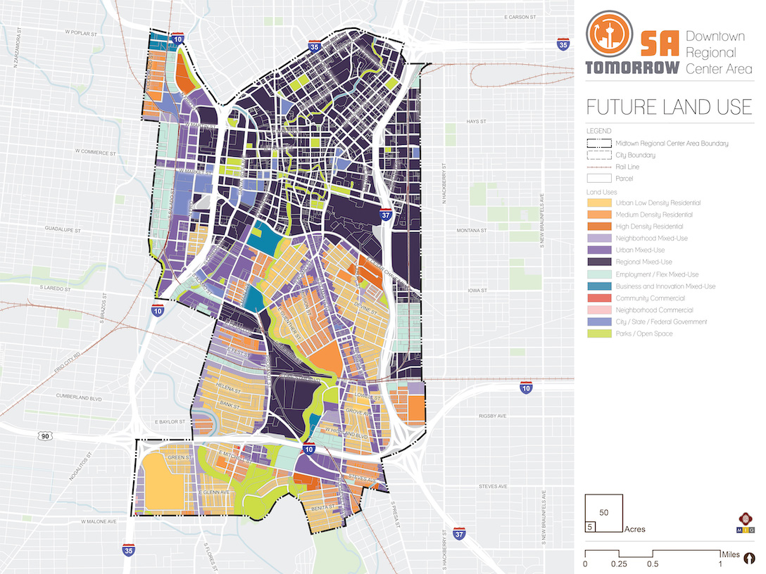
Land Use
The Downtown Area Regional Center future land use plan supports the SA Tomorrow Comprehensive Plan, Multimodal Transportation Plan, and Sustainability Plan. It also draws on recommendations from the SA Corridors Strategic Framework Plan and implements the Vision, Goals, and Plan Framework for the Downtown Area.
Downtown continues to contain a mixture of uses at higher densities than what is generally found in other areas of the city. Transitions to adjacent neighborhoods and centers are important, as are adaptive reuse and repurposing of legacy properties within the plan area. Historic neighborhoods and commercial areas support and reinforce the commercial core of the city, and the transportation network connects Downtown to the larger region through transit, trails and other forms of multi-modal transportation
The following sections describe the general land use patterns of the Downtown Area Regional Center. Recommendations for implementing the land use plan follow, and the full catalogue of land use categories adopted in the Unified Development Code (UDC) are found at the end of this section for reference.
It is important to note that the land use classifications do not alter any historic designation or other approved design criteria for existing neighborhoods. It is the intent of this Plan to preserve the character and identity of the historic neighborhoods of the city, in terms of use and of design.
Residential Areas
As Downtown is the center of a large metropolitan area, many of the residential uses are generally higher in density than those found in other regional centers throughout the city. Residential uses in Downtown include urban low density residential, medium density residential and high density residential.
Neighborhood Areas
The neighborhood areas in the Downtown Area Regional Center are classified as either Urban Low Density Residential or Medium Density Residential on the future land use map. These are intended to be primarily quiet, stable residential places that retain their character in the future. The future land use plan anticipates moderate growth of additional households in these neighborhoods, primarily where existing zoning supports such growth and where potential enhanced transit corridors and station areas create opportunities for more residents to access transit amenities. Commercial businesses should generally not encroach into these areas as they may cause disruption to quality of life and divert commercial activity away from places where it is specifically desired, however small scale retail and service uses supporting adjacent residences may be appropriate.
High-Density Residential Areas
Most of the high-density residential property in the Downtown Area Regional Center has a land use designation of mixed-use. This is to encourage the integration of residential and commercial development, in order to decrease vehicle trips and create a more pedestrian-oriented Downtown environment. However, several locations that are already classified as High-Density Residential, such as the former Victoria Courts site in the area between Cesar Chavez Boulevard, Labor Street, Leigh Street, and IH-37, retain the designation solely for High-Density Residential and do not include an element of commercial development. The High-Density Residential designation therefore expressly calls for residential development.
Mixed-Use Centers and Corridors
Most of the land in Downtown north of Caesar Chavez Boulevard is classified as some expression of mixed-use, continuing existing patterns of development and encouraging growth next to existing and planned transit corridors, major amenities, employment anchors, or existing commercial areas. Together the mixed-use areas will absorb development that would otherwise pressure traditional neighborhoods and instead support high-quality transit service, great amenities and public spaces, and housing and economic opportunity for existing and future residents.
Regional Mixed-Use
The Downtown core is classified as Regional Mixed-Use. Traditionally the economic and civic hub of the entire City, this area calls for the highest expression of density and intensity in the land use categories available. This is also in keeping with existing development patterns. Additionally, the majority of the area currently zoned “D” Downtown District, the River North area, the Lone Star Brewery area, and a few other locations are designated Regional Mixed-Use. Regional Mixed-Use allows for very high residential densities and encourages retail and commercial uses on lower floors. High rise office buildings may be appropriate for land classified as Regional Mixed-Use, although the scale of development should be respectful of adjacent traditional neighborhoods.
Urban Mixed-Use
Urban Mixed-Use is an intermediate intensity mixed-use classification and buildings are typically mid-rise or even just a few stories in height. Much of the land next to major corridors like Frio Street, South Alamo, South St. Mary’s and South Presa are designated Urban Mixed-Use.
Neighborhood Mixed-Use
The lowest intensity mixed-use land use category is Neighborhood Mixed-Use. This encourages a mixture of residential and commercial uses in areas with fewer people and less activity. Buildings are not very tall, they have a smaller footprint, and the lot sizes are often small. This land use classification is found along South Flores Street, south of South Alamo Street, as well as the South Flores and IH-35 corridors near Burbank High School. The intent is for these Neighborhood Mixed-Use areas to provide a mixture of uses that serve surrounding communities in a walkable environment, without significantly increasing traffic levels or the scale of development.
Commercial Areas
Most of the commercial uses in the Downtown Area Regional Center area are classified as mixed-use, rather than strictly commercial. There are, however, a few properties south of IH-10/ US Highway 90 which are classified as Community Commercial and Neighborhood Commercial, which are existing clusters of community serving businesses. These designations do not include a residential component.
Other Employment Areas
While designated mixed-use and commercial areas will support a variety of businesses and employment opportunities, there are three land use designations in this area that also have an impact on employment: City, State and Federal Government, Employment/Flex Mixed-Use, and Business/Innovation Mixed-Use.
City/State/Federal Government
Government properties are classified as distinct from other properties because their use and development are regulated differently. These properties, which include City Hall, Public Safety Headquarters, Haven for Hope, the Central Library, Fire Stations, Alamo Plaza and the Federal Court Building, are classified as City/State/Federal Government on the Future Land Use Map.
Employment/Flex Mixed-Use
There are many areas in the Downtown Area Regional Center which have historically been used for industrial purposes and which supported a variety of blue color jobs, but which have or could evolve into areas with a mix of employment, industrial arts, craft industries, creative spaces, and residences. Employment/Flex Mixed-Use properties are typically smaller-scale properties in historically industrial areas which could be re-purposed or re-used for industrial arts, craft industries, and as live-work properties, and are often interspersed along neighborhood edges. Most of the Employment/Flex Mixed-Use in the Downtown Area is found west of the University of Texas at San Antonio (UTSA) campus, between IH37 and Cherry Street south of East César E. Chavez Boulevard, north of Lone Star Boulevard between Probandt and South Flores streets, and near the intersection of Steves Avenue and Mission Road.
Business/Innovation Mixed-Use
Business/Innovation Mixed-Use is intended for campus-scale development for industrial uses with office, commercial, and residential uses in a cohesive setting. Although industrial in nature, these properties should generally have their activity housed indoors, and, though requiring buffers associated with industrial uses, they do not have the same environmental impacts as conventional industrial uses. There are limited instances of Business/Innovation Mixed-Use in the Downtown Area Regional Center, due to the historic and existing patterns of use in the area. HEB Grocery Headquarters, Pioneer Flour Mill, and EPIcenter are among the designated properties with this category. Other areas are found at the northwest corner of the plan area near the intersection of North Frio Street and West Poplar Street along IH-10 at the boundary of the Regional Center plan area.
Parks and Open Spaces
Parks and open spaces are important organizing features in the Downtown Area Regional Center. The San Antonio River connects Alamo Plaza with the historic missions to the south, including Mission Concepcion, which is located within this plan area. North of Market Street, traditional plazas and block parks provide green space and gathering places for Downtown. Like government uses, public parks and open spaces are treated as a separate land use category on the Future Land Use Map.
Land Use Recommendations
Four land use recommendations are identified to support the future land use plan for the Downtown Area Regional Center. In the Implementation section of the plan, specific strategies are provided for each of the following recommendations.
Recommendation #1:
Create transitions in scale and intensity between Downtown and surrounding areas to encourage greater integration of these areas with Downtown.North of Downtown is the Midtown Area Regional Center, which contains significant institutional properties to the north of IH-35. Higher densities can be accommodated in this part of Downtown, but right of way configuration, lot sizes, and existing design standards for districts such as River North should be factors in determining the form of development in the future.
The Eastside Community Area is home to historic neighborhoods that were some of the first streetcar suburbs connected to Downtown, though the area of the Eastside within this Regional Center plan is primarily industrial. As the properties along the east side of IH-37 are repurposed, development should decrease in size and mass along Cherry Street to respect the traditional neighborhoods of the Eastside Community Area.
The Westside Community Area is another historic, early suburb with strong ties to Downtown. Because of the difference in intensity of development in the community, as compared to that in the Downtown core, development west of IH-35 should also transition from high-density, downtown-scale buildings along Frio Street to medium density, mid-rise and smaller buildings with a flexible range of uses west of Salado Street.
Due to the presence of VIA’s central office in this part of Downtown, the strong transit ridership of the Westside community, and the institutional uses in this part of downtown, transit-supportive land use and transit-oriented development should be a priority in this area. Building heights for new development should transition gradually from surrounding properties when possible, and setbacks should be consistent along major thoroughfares and transit corridors to create a positive pedestrian environment.
Recommendation #2:
Evaluate and revise the various tools that the City uses to guide development in the Downtown Area so that they are consistent with SA Tomorrow and the Downtown Area Regional Center Plan.Recommendation #3:
Evaluate and consider revisions to the 'D' Downtown Zoning District to more clearly differentiate the scale of development and the desired land use pattern within the Central Business District.Recommendation #4:
Update the Unified Development Code to support transit-supportive development, mixed-use corridors and centers, and a high-quality public realm, and initiate rezoning in selected mixed-use corridors and focus areas.Implementing the Downtown future land use plan will require a coordinated approach to update multiple sections of the Unified Development Code. New mixed-use and revised transit-oriented zoning districts should be written into the Unified Development Code and the City should lead in rezoning selected portions of focus areas and mixed-use corridors using these new zoning districts. The new transit-oriented and mixed-use zoning should encourage vertical mixed-use development, with public-facing commercial activity on ground floors, and offices and/or residences above. New automobile-oriented uses and site designs should be discouraged or prohibited in these zoning categories.
Successful and vibrant commercial areas featuring significant pedestrian activity and a diverse mix of business and services rely on a substantial population to support them. Their success also relies on businesses being sufficiently concentrated, rather than overly spread out across long travel corridors, interspersed with vacant areas and abundant surface parking areas. Accordingly, to activate underused places, meet the city’s housing goals, and encourage concentrated vibrant commercial areas, multi-family residential development is encouraged in mixed-use corridors and focus areas.
In areas designated Employment/Flex Mixed-Use or Business/Innovation Mixed-Use, adaptive re-use of older properties is encouraged. However, existing buildings may not meet the setback, height and use requirements of the existing zoning categories. In order to accommodate these uses, a new mixed-use zoning category may be needed, which allows for industrial arts, live-work, craft industry, neighborhood services, and residential uses. Setbacks, heights and other site design requirements will also need flexibility to accommodate existing property constraints, as many of these properties were historically zoned for industrial uses, without many limitations on site design. These two mixed-use land use categories are also effective at preserving legacy industrial properties that should be preserved and repurposed.
Recommendation #5:
Discourage incremental rezoning (both up-zoning and down-zoning) in Downtown neighborhood areas.Neighborhood stability, ensuring adequate housing supply, and fostering vibrant, pedestrian-oriented commercial areas are important elements of this Plan. In the Downtown Area Regional Center Plan, there is substantial supply of land available for redevelopment in mixed-use corridors and focus areas; however, there is a forecasted need for several thousand additional housing units by 2040. Accordingly, new, incompatible commercial development in neighborhood residential areas is discouraged. To support stability, predictability, and modest growth in housing supply and choice within neighborhood areas, down-zoning residential properties to restrict housing unit density and exclude potential future neighborhood residents is generally discouraged. Similarly, changing the base zoning of residentially zoned properties in neighborhood residential areas to allow more density is also generally discouraged, except in cases where large vacant, commercial, or institutional sites are redeveloped to create new missing middle housing.
Where additional households or uses beyond those currently allowed may be appropriate, conditional rezoning is a mechanism that provides more certainty as to development outcomes and the future evolution of a property. Accordingly, to support stability and predictability while supporting other community goals, such as incentivizing affordable housing, senior housing, housing for people with disabilities, housing with multiple bedrooms for families, and reinvestment in existing structures that contribute to the essential character of a neighborhood, conditional rezoning is preferred over changing the base zoning district of properties in residential areas of the neighborhood.
Similarly, to implement the recommendations of the Mayor’s Housing Policy Task Force to incentivize certain types of housing, some combination of Unified Development Code amendments and rezoning in neighborhood residential areas that simultaneously encourages more housing for people, while providing more certainty on building and site design is encouraged.
Recommendation #6:
Coordinate existing public and private parking resources to facilitate more effective management and utilization for existing development and stronger assurance of supply and access to parking for new development.Parking structures and surface parking lots are dominant features in the Downtown Area, particularly in the Downtown Core. Many of the area’s parking facilities are single use structures with big, blank walls at the street level that discourage pedestrian and bicycle activity, and curb cuts that create unsafe conditions on sidewalks. Surface parking lots create gaps in activity and are typically unattractive without landscaping or shade features. Meanwhile, many new developments require adequate amounts of parking to serve businesses and residents. The continuing redevelopment of the Downtown Area will require creative thinking to resolve design issues related to off – street parking structures and lots; reduce parking needs for existing and new development; encourage use of mass transit to reduce overall parking demand; and leverage new parking technologies to manage future demand.
Future Land Use Categories
As described above, the Downtown Area Regional Center Plan includes a range of land use designations that represent the unique character of the area, while encouraging and supporting development patterns that reflect the goals of the SA Tomorrow Comprehensive Plan and the preferences of the Downtown community. Listed below is the full list of land use categories adopted by City Council into the Unified Development Code (UDC), Chapter 35, on October 11, 2018. Each category listed includes a description, general guidance on where the land use designation is most appropriate, and a list of allowable zoning districts.
Residential Estate
Residential Estate includes large lot single-family detached houses on individual estate-sized lots or in conservation subdivisions. This form of development should be located away from major arterials, and can include certain nonresidential uses such as schools, places of worship, and parks that are centrally located for convenient neighborhood access. Permitted zoning districts: FR, R-20, RE, and RP.
Typical densities in this land use category would be up to 2 dwelling units per acre.
Low Density Residential
Low Density Residential includes single-family detached houses on individual lots, including manufactured and modular homes. This form of development should not typically be located adjacent to major arterials. This land use category can include certain nonresidential uses such as schools, places of worship, and parks that are centrally located for convenient neighborhood access. Permitted zoning districts: R-4, R-5, R-6, NP-8, NP-10, and NP-15.
Typical densities in this land use category would range from 3 to 12 dwelling units per acre.
IDZ and PUD may be considered consistent with this land use category, provided the permitted uses included on the zoning site plan and zoning ordinance are consistent with the uses and densities outlined above.
Urban Low Density Residential
Urban Low Density Residential includes a range of housing types including single-family attached and detached houses on individual lots, small lot residences, duplexes, triplexes, fourplexes, cottage homes, manufactured homes, low-rise garden- style apartments, and manufactured home parks. This land use category may also accommodate small scale retail and service uses that are intended to support the adjacent residential uses. Other nonresidential uses, including, but not limited to, schools, places of worship, and parks are appropriate within these areas and should be centrally located to provide easy accessibility. Permitted zoning districts: R-3, R-4, R-5, R-6, RM-5, RM-6, MF-18, MH, MHC, MHP, and NC.
Typical densities in this land use category would range from 7 to 18 dwelling units per acre.
IDZ, PUD, MXD, and TOD may be considered consistent with this land use category, provided the permitted uses included on the zoning site plan and zoning ordinance are consistent with the uses and densities outlined above.
Medium Density Residential
Medium Density Residential accommodates a range of housing types including single-family attached and detached houses on individual lots, manufactured and modular homes, duplexes, triplexes, fourplexes, and low-rise, garden-style apartments with more than four (4) dwelling units per building. Cottage homes and very small lot single-family houses are also appropriate within this land use category. Higher density multi-family uses, where practical, should be located in proximity to transit facilities. Certain nonresidential uses, including, but not limited to, schools, places of worship, and parks are appropriate within these areas and should be centrally located to provide easy accessibility. Permitted zoning districts: R-3, R-4, RM-4, RM-5, RM-6, MF-18, MF-25, MF-33, MH, MHC, and MHP.
Typical densities in this land use category would range from 13 to 33 dwelling units per acre.
IDZ, PUD, MXD, and TOD may be considered consistent with this land use category, provided the permitted uses included on the zoning site plan and zoning ordinance are consistent with the uses and densities outlined above.
High Density Residential
High Density Residential includes low-rise to mid-rise buildings with four (4) or more dwelling units in each. High density residential provides for compact development including apartments, condominiums, and assisted living facilities. This form of development is typically located along or near major arterials or collectors. High density multi-family uses should be located in close proximity to transit facilities. Certain nonresidential uses, including, but not limited to schools, places of worship, and parks are appropriate within these areas and should be centrally located to provide easy accessibility. This classification may be used as a transitional buffer between lower density residential uses and nonresidential uses. High density residential uses should be located in a manner that does not route traffic through lower-density residential uses. Permitted zoning districts: RM-4, MF-25, MF-33, MF-40, MF-50, MF-65, MH, MHC, and MHP.
Typical densities in this land use category would range from 25 to 50 dwelling units per acre.
IDZ, PUD, MXD, and TOD may be considered consistent with this land use category, provided the permitted uses included on the zoning site plan and zoning ordinance are consistent with the uses and densities outlined above.
Neighborhood Commercial
Neighborhood Commercial includes smaller intensity commercial uses such as small-scale retail or offices, professional services, and convenience retail and services that are intended to support the adjacent residential uses. Neighborhood commercial uses should be located within walking distance of neighborhood residential areas. Special consideration should be given to pedestrian and bicycle facilities that connect neighborhoods to commercial nodes. Permitted zoning districts: O-1, NC, and C-1.
IDZ, PUD, MXD, TOD, and MPCD may be considered consistent with this land use category, provided the permitted uses included on the zoning site plan and zoning ordinance are consistent with the uses and densities outlined above.
Community Commercial
Community Commercial includes offices, professional services, and retail uses that are accessible to bicyclists and pedestrians and linked to transit facilities. This form of development should be located in proximity to major intersections or where an existing commercial area has been established. Community commercial uses are intended to support multiple neighborhoods, have a larger market draw than neighborhood commercial uses, and attract patrons from the neighboring residential areas. All off-street parking and loading areas adjacent to residential uses should include landscape buffers, lighting and signage controls. Examples of community commercial uses include, but are not limited to, cafes, offices, restaurants, beauty parlors, neighborhood groceries or markets, shoe repair shops and medical clinics. Permitted zoning districts: O-1.5, NC, C-1, and C-2.
IDZ, PUD, MXD, TOD, and MPCD may be considered consistent with this land use category, provided the permitted uses included on the zoning site plan and zoning ordinance are consistent with the uses and densities outlined above.
Regional Commercial
Regional Commercial includes high intensity uses that draw customers from both adjacent communities as well as the larger metropolitan region. Regional commercial uses are typically located in general proximity to nodes along expressways or major arterial roadways and incorporate high-capacity transit facilities. Regional Commercial uses should incorporate well-defined entrances, shared internal circulation, limited curb cuts to expressways and arterial streets, sidewalks and shade trees in parking lots, landscaping between the parking lots and roadways, and well- designed monument signage. Examples of regional commercial uses include, but are not limited to, movie theaters, plant nurseries, automotive repair shops, fitness centers, home improvement centers, hotels and motels, mid- to high-rise office buildings, and automobile dealerships. Permitted zoning districts: O-1.5, O-2, C- 2, C-3, L, and BP.
IDZ, PUD, MXD, TOD and MPCD may be considered consistent with this land use category, provided the permitted uses included on the zoning site plan and zoning ordinance are consistent with the uses and densities outlined above.
Neighborhood Mixed-Use
Neighborhood Mixed-Use contains a mix of residential, commercial, and institutional uses at a neighborhood scale. Within mixed-use buildings, residential units located above first floor are encouraged. Typical first floor uses include, but are not limited to, small office spaces, professional services, and small scale retail establishments and restaurants. The mix of uses may be vertically or horizontally distributed, and there is no requirement that a single building contain more than one use. Live/work housing options are permissible in Neighborhood Mixed-Use area to ensure access to housing options and services within close proximity for the local workforce. Where practical, buildings are situated close to the public right-of-way, and parking is located behind buildings. Parking requirements may be minimized using a variety of creative methods, such as shared or cooperative parking agreements, to maximize land available for housing and community services. Pedestrian spaces are encouraged to include lighting and signage, and streetscaping should be scaled for pedestrians, cyclists, and vehicles. Properties classified as Neighborhood Mixed-Use should be located in close proximity to transit facilities. Permitted zoning districts: RM-4, RM-5, RM-6, MF-18, O-1, NC, C-1, MH, MHC, MHP, FBZD, AE-1, and AE-2.
IDZ, PUD, MXD, TOD and MPCD may be considered consistent with this land use category, provided the permitted uses included on the zoning site plan and zoning ordinance are consistent with the uses and densities outlined above.
Urban Mixed-Use
Urban Mixed-Use contains a mix of residential, commercial, and institutional uses at a medium level of intensity. Urban mixed-use development is typically larger-scale than Neighborhood Mixed-Use and smaller-scale than Regional Mixed-Use, although many of the allowable uses could be the same in all three categories. Building footprints may be block-scale, but could be smaller depending on block configuration and overall development density. Typical first floor uses include, but are not limited to, professional services, offices, institutional uses, restaurants, and retail including grocery stores. The mix of uses may be vertically or horizontally distributed, and there is no requirement that a single building contain more than one use. Live/work housing options are permissible in Urban Mixed-Use areas to ensure access to housing options and services within close proximity for the local workforce. Structured parking is encouraged in Urban Mixed-Use category, but is not required. Parking requirements may be satisfied through shared or cooperative parking agreements, which could include off-site garages or lots. The Urban Mixed-Use category should be located in proximity to transit facilities. Permitted zoning districts: RM-4, RM-5, RM-6, MF-18, MF-25, MF-33, MF-40, O-1, O-1.5, C-1, C-2, MH, MHP, MHC, FBZD, AE-1, AE-2, AE-3, and AE-4.
IDZ, PUD, MXD, TOD and MPCD may be considered consistent with this land use category, provided the permitted uses included on the zoning site plan and zoning ordinance are consistent with the uses and densities outlined above.
Regional Mixed-Use
Regional mixed-use contains residential, commercial and institutional uses at high densities. Regional Mixed-Use developments are typically located within regional centers and in close proximity to transit facilities, where mid-rise to high-rise buildings would be appropriate. Typical lower floor uses include, but are not limited to, offices, professional services, institutional uses, restaurants, and retail including grocery stores. The mix of uses may be vertically or horizontally distributed, and there is no requirement that a single building contain more than one use. Live/work housing options are permissible in Regional Mixed-Use areas to ensure access to housing options and services within close proximity for the local workforce. Where feasible, development is ideally built at the block scale, with minimum building setbacks. Parking requirements may be satisfied through shared or cooperative parking agreements, which can include off-site garages or lots. If parking requirements are satisfied on-site, structured parking is encouraged. Pedestrian spaces are encouraged to be generous in width and lighting, with streetscaping and signage scaled to pedestrians. Regional mixed-use projects encourage incorporation of transit facilities into development. Permitted zoning districts: MF-33, MF-40, MF-50, MF-65, O-1.5, O-2, C-2, C-3, D, ED, FBZD, AE-1, AE-2, AE-3, and AE-4.
IDZ, PUD, MXD, TOD and MPCD may be considered consistent with this land use category, provided the permitted uses included on the zoning site plan and zoning ordinance are consistent with the uses and densities outlined above.
Employment/Flex Mixed-Use
Employment/Flex Mixed-Use provides a flexible live/work environment with an urban mix of residential and light service industrial uses. Uses include smaller-scale office, retail, art studio warehouses, art-oriented fabrication, creative businesses and work spaces, and cottage industrial and fabrication uses. Adaptive uses of vacant or underutilized structures are encouraged to provide residential urban infill and appropriate employment opportunities within or in close proximity to neighborhoods. Buildings have a smaller footprint and can closely resemble campus-like development across multiple sites or with several multi-functioning buildings on one site. Permitted zoning districts: RM-4, MF-18, MF-25, MF-33, O-1, O-1.5, C-1, C-2, L, AE-1, AE-2, AE-3, and AE-4.
IDZ, PUD, MXD, TOD and MPCD may be considered consistent with this land use category, provided the permitted uses included on the zoning site plan and zoning ordinance are consistent with the uses and densities outlined above.
Business/Innovation Mixed-Use
Business/Innovation Mixed-Use accommodates industrial uses with office, commercial, and residential uses, all within a cohesive setting, on a larger scale and within larger footprints than the Employment/Flex Mixed-Use category. Industrial arts workshops, high tech fabrication, processing and assembly, and other industrial uses are permitted, in addition to commercial uses. Vocational training, technological learning centers, medical campuses, and research/development institutions are also appropriate for these spaces. Additional environmental performance standards should be employed for properties designated as Business/Innovation Mixed-Use, such as hours of activity, loading, noise levels and lighting, to ensure that the intensity of the industrially oriented uses is comparable to that of the other non-residential uses. The mix of uses may be either vertically or horizontally distributed. Live/work housing options are permissible in Business/Innovation mixed-use areas to ensure access to housing options and services within close proximity of business innovation areas for the local-workforce. Business/Innovation mixed-use should incorporate transit and bicycle facilities to serve the training and employment base. Permitted zoning districts: RM-4, MF-18, MF-25, O-1.5, O-2, C-2, C-3, L, I-1, MI-1, BP, AE-1, AE-2, AE-3, and AE-4.
IDZ, PUD, MXD, TOD and MPCD may be considered consistent with this land use category, provided the permitted uses included on the zoning site plan and zoning ordinance are consistent with the uses and densities outlined above.
Light Industrial
Light Industrial includes a mix of manufacturing uses, business park, and limited retail/service uses that serve the industrial uses. Industrial uses should be screened and buffered from adjoining non-industrial uses. Any outside storage should be under a roof and screened from public view. Examples of light industrial uses include drug laboratories, furniture wholesalers, lumberyards, food production, and warehousing. Permitted zoning districts: L, I-1, MI-1, and BP.
IDZ, TOD, and MPCD may be considered consistent with this land use category, provided the permitted uses included on the zoning site plan and zoning ordinance are consistent with the uses and densities outlined above.
Heavy Industrial
Heavy Industrial includes heavy manufacturing, processing and fabricating businesses. Heavy industrial uses shall be concentrated at arterials, expressways, and railroad lines. This category is not compatible with neighborhood-scaled categories or those that permit residential zoning. Heavy Industrial should be separated from non-industrial uses by an allowable land use or a significant buffer. Examples of heavy industrial uses include auto manufacturing, battery manufacturing, and petro chemical bulk storage. Permitted zoning districts: I-1, I-2, MI-1, MI-2, QD, and SGD.
Agricultural
Agricultural includes crop agriculture, ranching, and related agribusiness practices. Single-family detached houses and detached accessory dwelling units are permitted on agricultural and ranch lands at very low densities or in conservation subdivisions that will not interfere with agricultural operations. Limited commercial uses directly serving agricultural and ranching uses, such as farmers markets, nurseries, stables, bed and breakfasts are permitted. To maintain scenic qualities, natural vegetative buffers, deeper setbacks, increased signage control, earthen drainage channels, and more restrictive access management standards are desired along major scenic corridors. Floodplain protection and buffer zones along creeks and rivers are instrumental in retaining rural character. Permitted zoning districts: RP and FR.
Parks/Open Space
Parks/Open Space may include, but is not limited to, large, linear, or unimproved land where conservation is promoted, and development is not encouraged due to the presence of topographic constraints or institutional uses on the site. Parks/Open Space may include utility corridors and public or private land uses that encourage outdoor passive or active recreation. Examples include city owned and/or operated pocket, regional, or linear parks, as well as private parks associated with subdivisions and neighborhood associations.
City/State/Federal Government
City/State/Federal Government includes areas owned and operated by a federal, state, or city agency. Examples may include government offices, public service facilities such as libraries and police stations, military bases, state colleges, and federal courts. This category does not apply to properties owned by a public agency but leased to and operated by another party.