Plan Framework
Amenities & Infrastructure
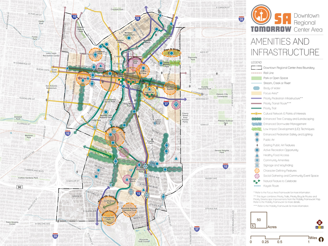
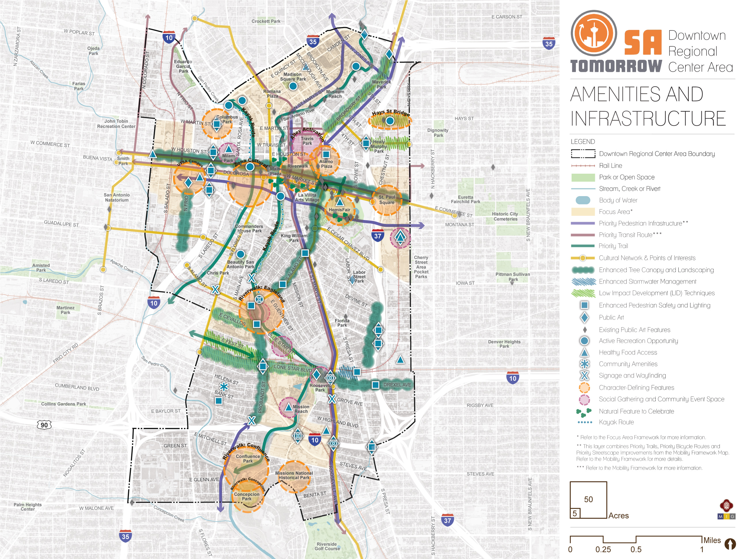
The map below highlights the Amenities & Infrastructure Framework recommendations identified for the Downtown Regional Center Area. Scroll down learn more about the vision for Amenities & Infrastructure in the Plan Area.
To provide specific feedback on the map, please click and drag a box on that location of the map and fill out the comment box. We would love to hear more from you!
Introduction
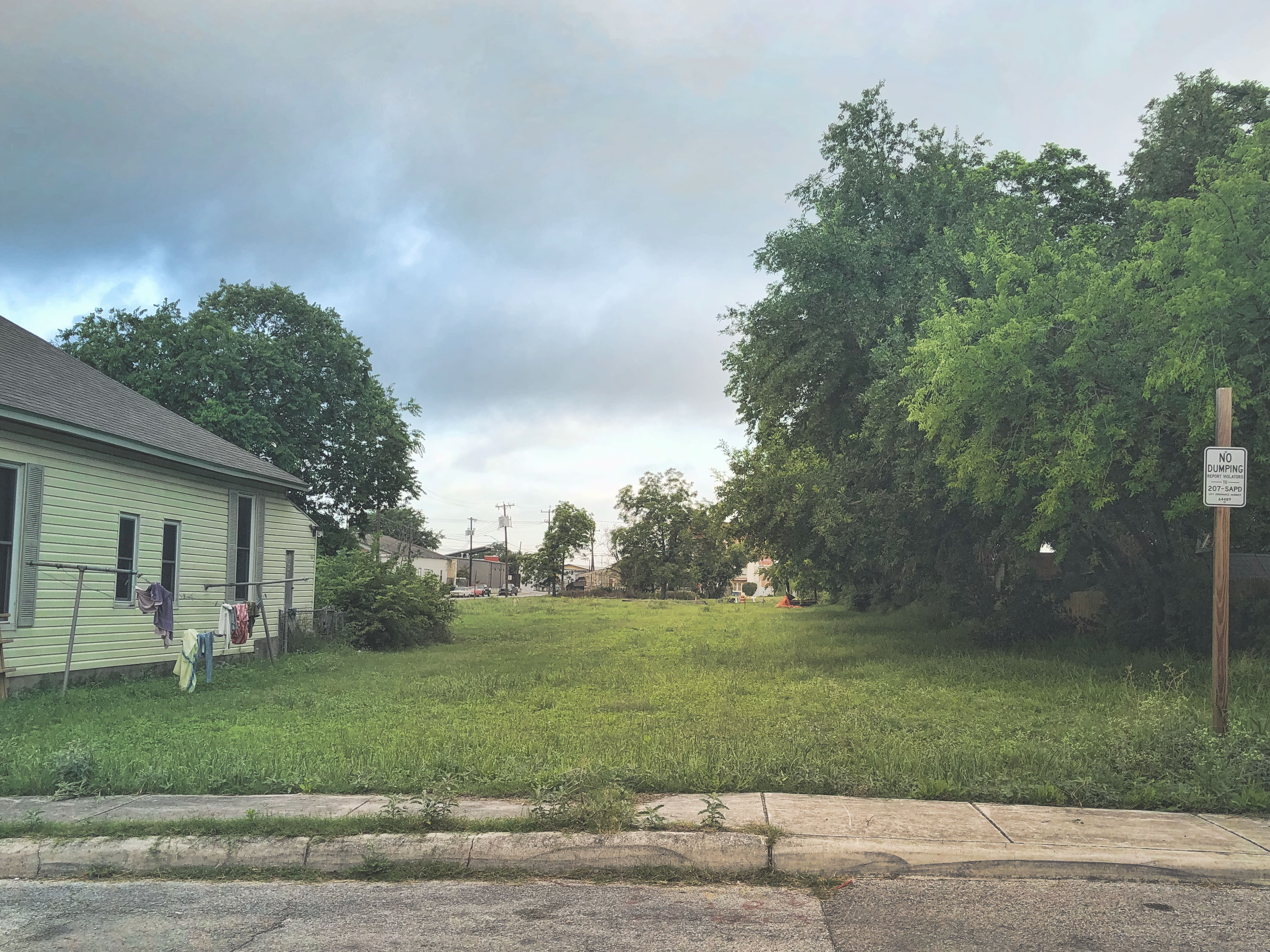
In the future, as more people live, work, and play in Downtown, quality of life should improve with better public spaces,arts and cultural events, better infrastructure, and more opportunities for people to make connections to surrounding areas and to each other. Mobility improvements will aid in accommodating different ways that people choose to get around, but there are many other elements to ensuring that moving from place to place is safe, comfortable and inviting. There are a variety of attractive streets and paths in and around Downtown and it will be important to better link these moving forward by filling gaps and prioritizing amenities between areas that are already pedestrian and bicycle friendly.
With the Downtown Area Regional Center being so diverse with the Downtown core, Hemisfair, River North, Zona Cultural, Vista Verde South and a host of other districts and neighborhoods, it is also critical that amenities are well distributed and do not serve only one area or one population. The types of infrastructure and amenities, and the manner in which they are provided, should be as diverse as the different sections of the Downtown Area Regional Center, but it is important that areas that have been neglected or overlooked in the past receive public and private investment in quality of life, placemaking, and placekeeping.
With the largest concentration of hospitality uses and other visitor amenities, it is also important that Downtown continues to add infrastructure, amenities and services for residents and employees. Downtown will continue to be a major visitor destination moving forward and it is important to stay competitive in this critical sector of the San Antonio economy. With that said, investments in places like Yanaguana Garden at Hemisfair illustrate how well-designed spaces and amenities can draw residents from around the city while also serving tourists and other visitors.
Amenities and Infrastructure Recommendations
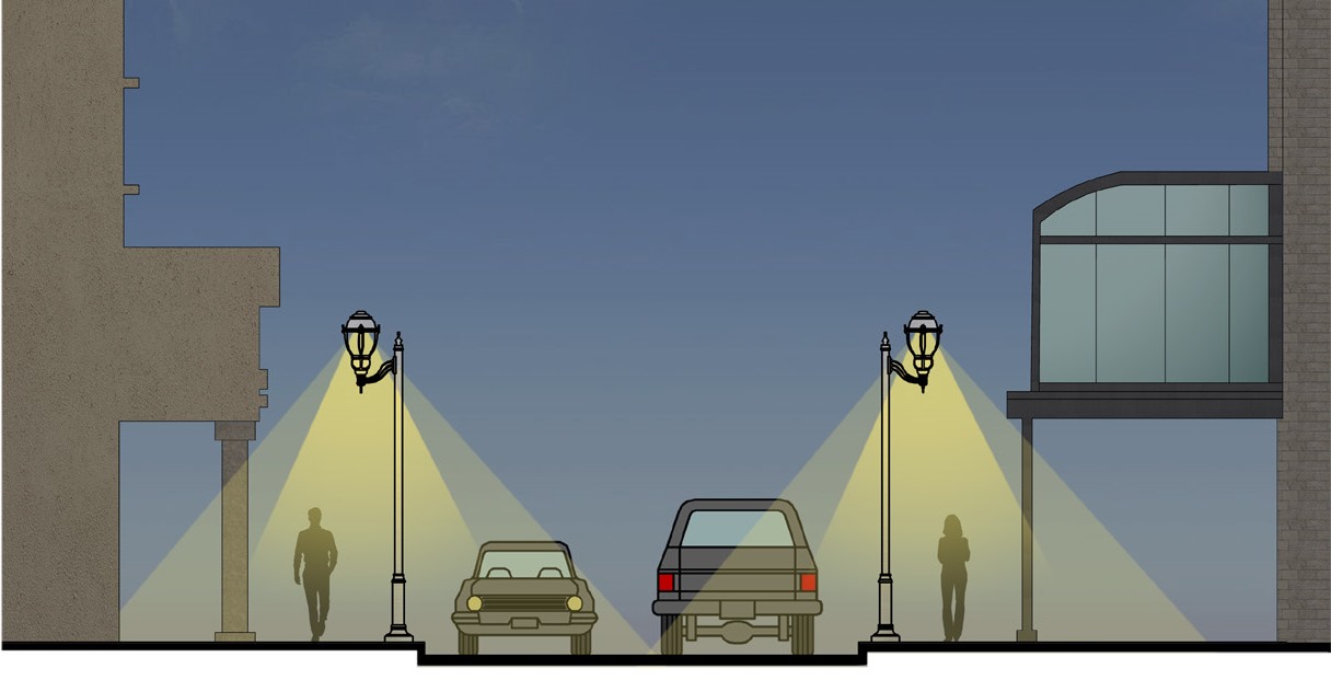
Houston Street Lighting Cross Section
Recommendation #1:
Include trees, shade, and high-quality lighting in mixed-use corridor and focus area redevelopment to create comfortable places to walk, explore, and stay.Walking is a preferred mode of travel within the Downtown core, but few people choose to walk outside in this area. In order for walking to be a viable and enjoyable choice for getting around, connecting to transit service, or parking once and visiting multiple destinations in the same area, a variety of improvements to the pedestrian experience are needed to promote more human scale frontages including preservation of tree canopy and increased provision of street trees; murals and green walls; and improved street lighting.
Downtown San Antonio is largely built out and the heat island effect is extremely pronounced, especially in the Downtown core. A person walking amongst trees and shade will feel several degrees cooler than someone fully exposed to the sun. Because most of Downtown’s mixed-use corridors are constrained by the original platting of the area, strong street walls with buildings close to the street and/or have been “improved” to provide as many lanes as possible for travelling vehicles, accommodating more trees in these highly urban environments is a challenge. At the same time, there is increasing demand for widening sidewalks, adding bicycle lanes, street parking, and other uses in the public right-of-way. However, trees are an important part of Downtown’s future. For growth and development to improve quality of life in Downtown, trees should be included with new private development and public investments in mixed-use areas.
Street lighting is also important in Downtown, especially in focus areas and mixed-use corridors for the same reasons that it is valued in neighborhood areas, primarily to make people feel safe, secure, and visible at night. However, street lighting in focus areas and mixed-use corridors can also contribute to the unique character of each area with decorative light fixtures/poles and can serve to highlight that a certain set of street segments or a mixed-use node at a particular intersection is special, with extra lighting that is intentionally designed to complement the character of the place and encourage night time use.
The City's Urban Lighting Master Plan was accepted in April 2019 to provide a uniform set of guidelines for lighting for various types of roadways, parks, art projects, and facilities. Guidelines recommended within the Lighting Master Plan should inform lighting improvements within the Downtown Area Regional Center as bond projects and other capital projects are implemented. As investments are made to implement the Urban Lighting Master Plan, street lighting should be installed at selected commercial mixed-use nodes within focus areas and mixed-use corridors identified in this Plan where the mix of uses, transit service, and density will support active pedestrian uses at night. This will reinforce the desire to have these neighborhood nodes serve as places for the community to gather. The Downtown Core Investment Area would benefit from an emphasis on decorative lighting at the street level to strengthen wayfinding onto and off of the San Antonio River Walk and to compliment the character of distinct neighborhoods and districts such as Zona Cultural.
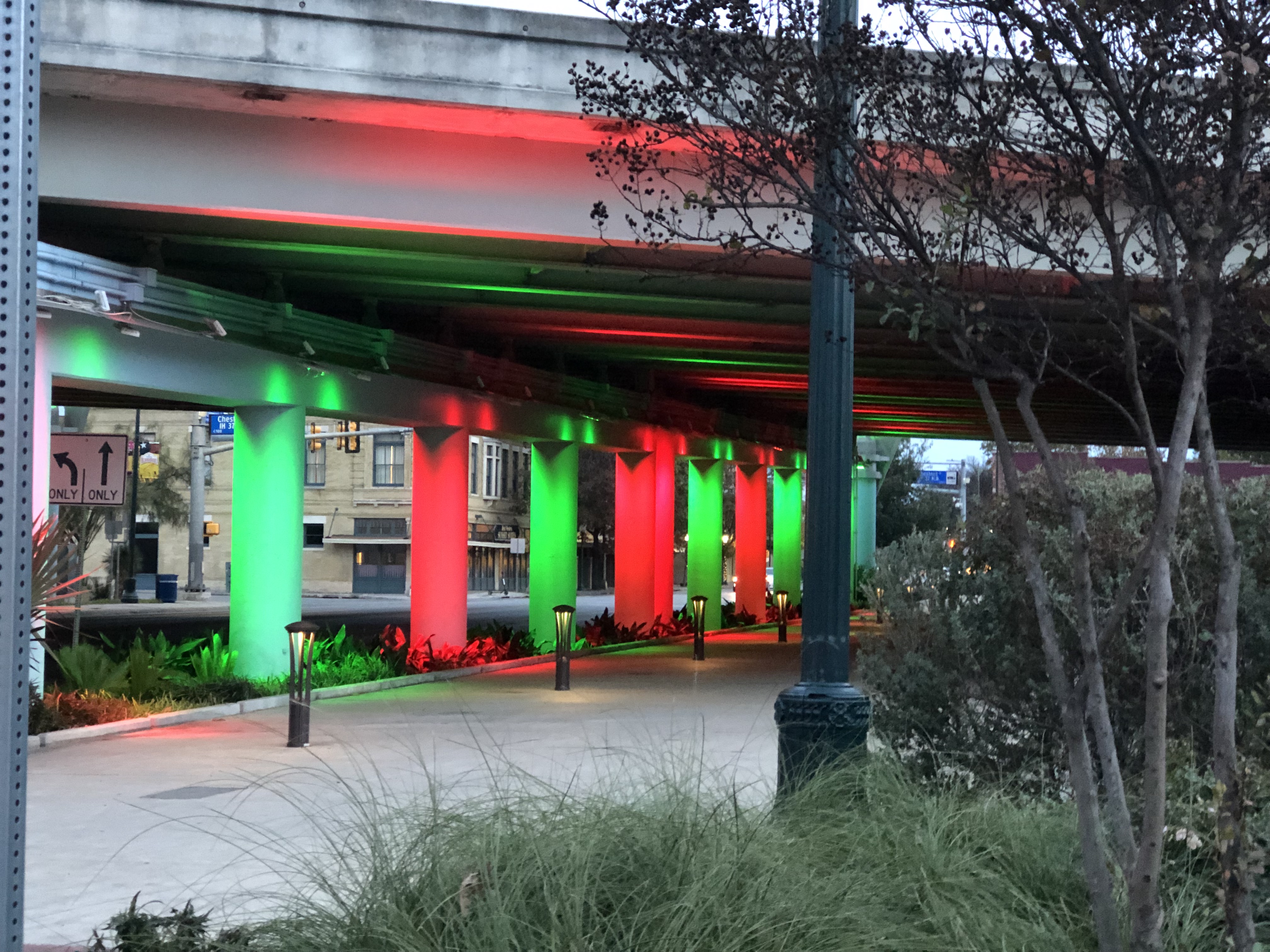
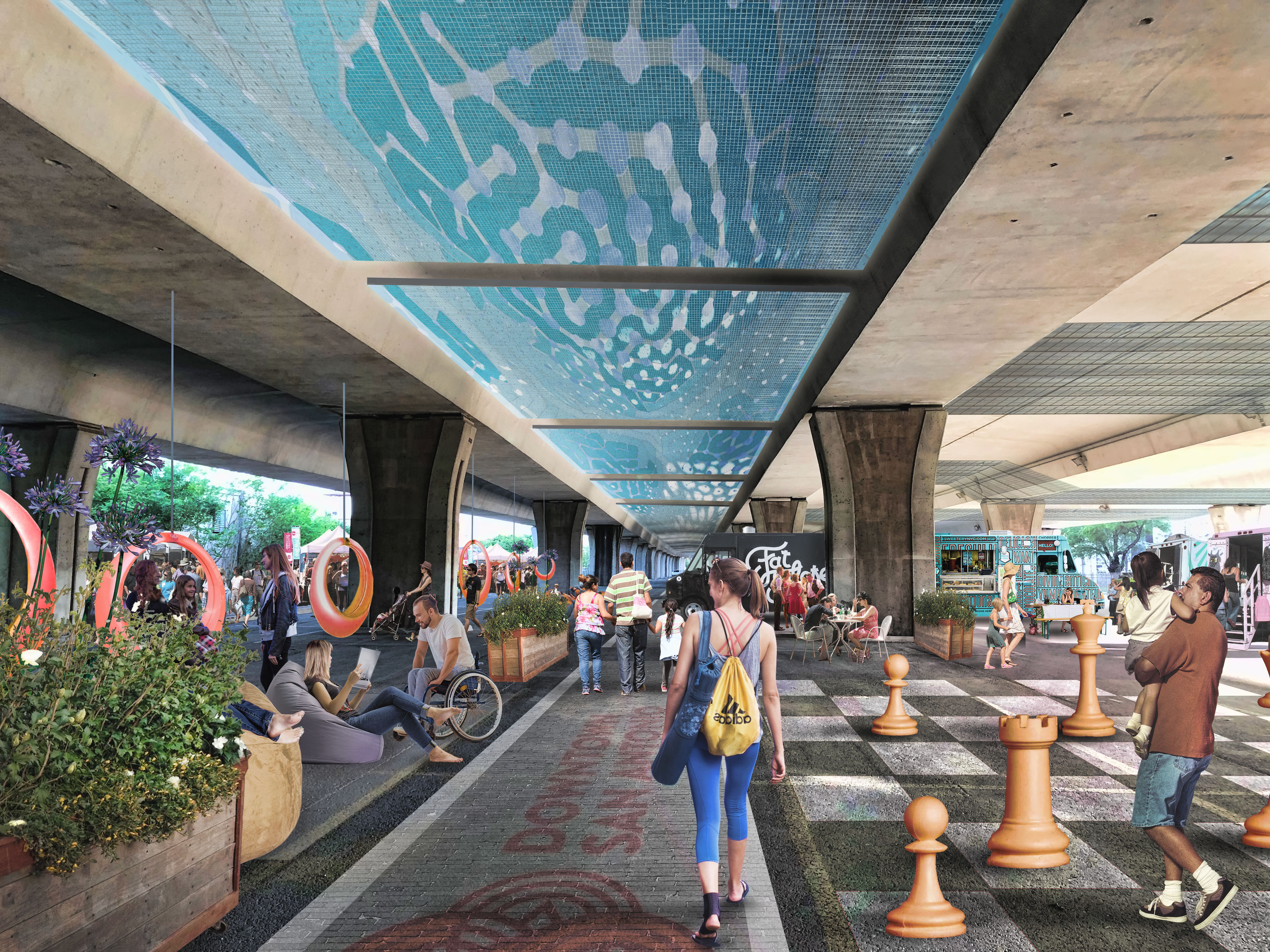
“Light Channels” by Bill FitzGibbons - Commerce Street Underpass
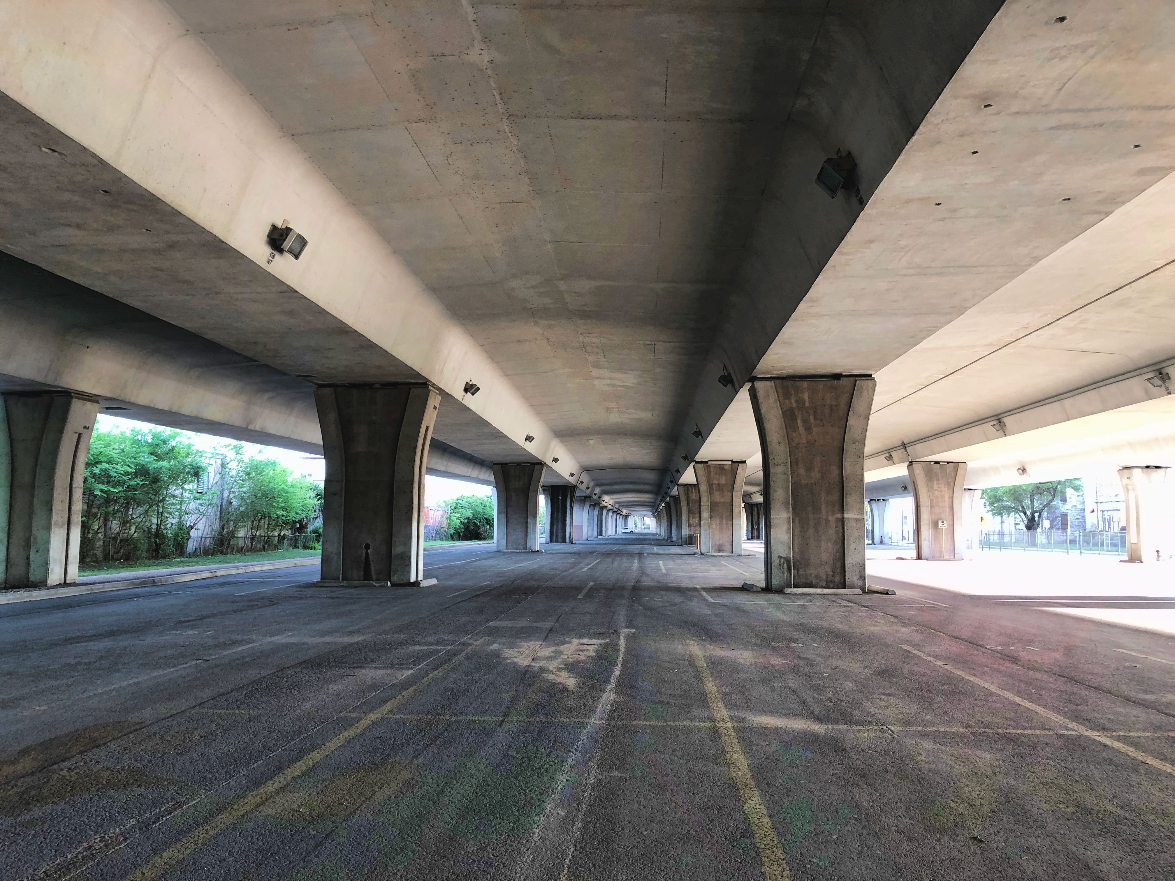
Decorative lighting underneath highway underpasses can encourage pedestrian connections to surrounding neighborhoods. However, more than lighting and art are needed to make highway underpasses feel comfortable, safe, and secure. Consistent with the Catalytic Projects and future land use map in this Plan, dense mixed-use development that serves a variety of users at all times of day will support an abundance of pedestrians and ground floor users. An abundance of fellow pedestrians can make underpasses feel more secure, and an enticing street scene on either side of a highway can draw people to cross from one side to the other. Temporary activation of the highway underpasses through lighting and art can also be an effective and transformative intervention in the short-term while long-term visions are being pursued.
Recommendation #2:
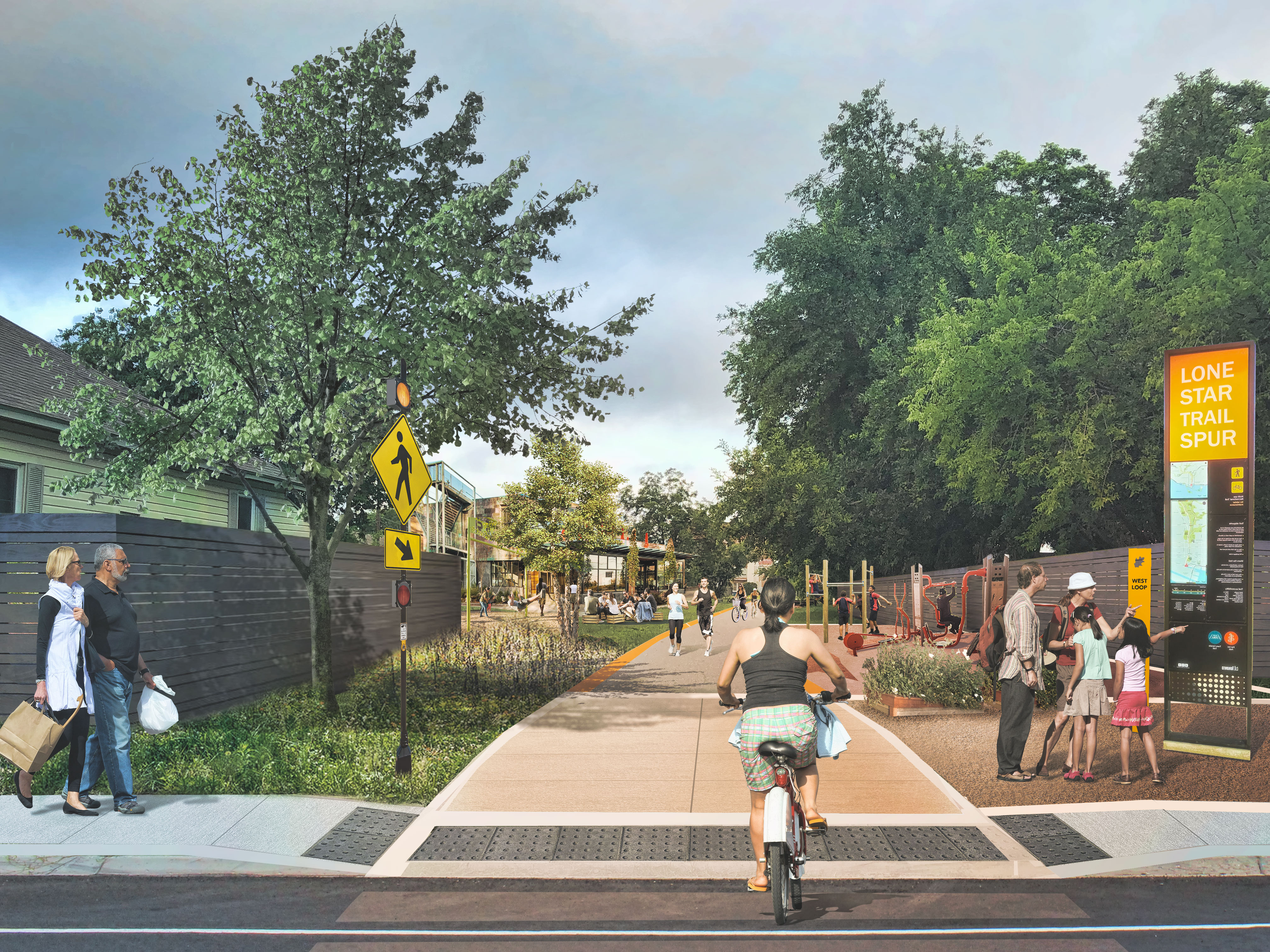
Better connect the many diverse cultural assets and amenities throughout the Downtown Area Regional Center using new and existing routes that accommodate pedestrians, bicyclists, and other personal mobility devices.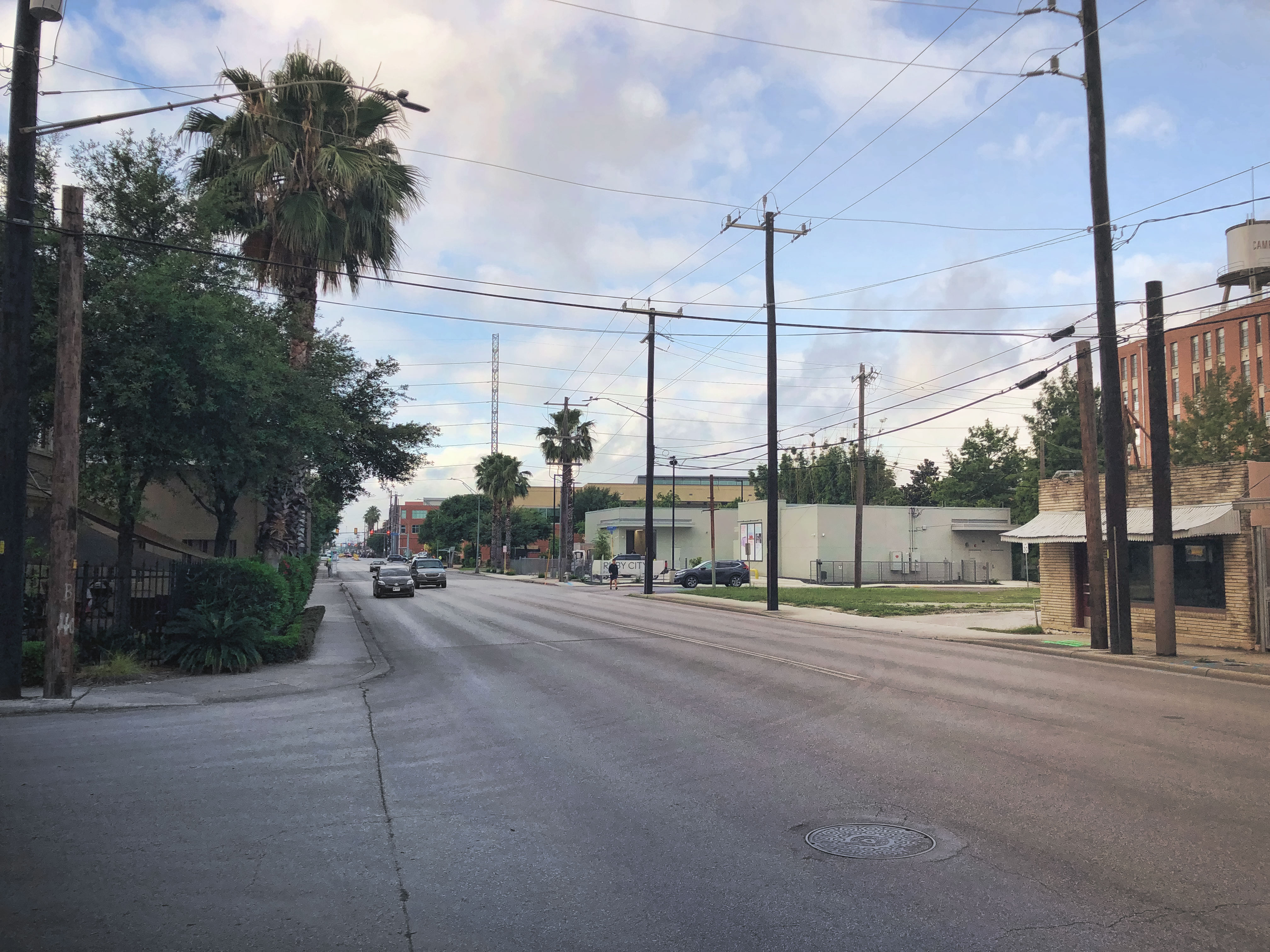
The Downtown Area is fortunate to have a diverse and robust collection of cultural assets and amenities, including historic landmarks, historic districts, museums, river and creek trails and pathways, parks, plazas, public art, studios, galleries and more. While it is relatively easy for people to move between the cultural assets and amenities within the immediate core of Downtown, there is increasing interest in experiencing areas beyond the historical core and using a variety of ways to get there. As the River Walk continues to attract visitors and the San Pedro Creek Culture Park is completed, there will also be a need to ensure that the connections between these off-street experience and streets nearby are maintained and enhanced. A “Cultural Network” system of urban pathways should be established to enhance and sustain connections to the community’s cultural assets. Many downtowns across the country are taking Indianapolis’ lead and designing urban pathways akin to the Indianapolis Cultural Trail. Of those communities working on similar culturally oriented infrastructure, San Antonio easily has the most robust collection of cultural assets and amenities, as well as significant pieces of pedestrian and bicycle infrastructure in place. A San Antonio Cultural Network can connect several areas of the Downtown Area Regional Center, dozens of cultural assets and amenities, and help to sustain and strengthen cultural resources which are already in place.
San Antonio’s Downtown is already touted for the River Walk network along the San Antonio River. This network will be enhanced with the addition of the San Pedro Creek Culture Park. As these waterway pathways and amenities mature, it will become even more important to ensure that signage and wayfinding helps pedestrians (and cyclists in certain locations) navigate between the waterway path level and the street level of Downtown.
Due to the success of the River Walk, there are instances of shops and restaurants presenting their major entry and frontage on the River Walk with a much less prominent frontage at street level. As Downtown see additional development and becomes even more vibrant, design of rehabilitated and new buildings should balance the activation of the waterway path level and street level.
Recommendation #3:
Develop stronger connections to character defining features and other areas outside the Downtown core by addressing barriers created by major infrastructure.The Downtown Area Regional Center has a number of character defining features. While many of them are located within the freeway loop and are concentrated in the historic Downtown core, the majority are actually outside this area and separated by major highways, railroads and other transportation infrastructure. For Downtown to feel and function like a single Regional Center that is well-connected and cohesive, it will be important for future investments to address the major barriers impeding safe and comfortable travel from place to place.
Highways IH-10, IH-35 and IH-37 create a series of raised highway infrastructure, underpasses, and berms surrounding Downtown and separating several subareas of the Regional Center from one another.
There are several active rails running through and along the edges of the Downtown Area Regional Center. Many of these railroad corridors are crossed by roadways and pedestrian and bicycle amenities are often constrained or absent from these corridors when they cross rails and improvements are necessary to comfortably serve pedestrians and bicyclists.
As more development occurs within the Downtown Area Regional Center, pedestrian, bicycle, shared micro-mobility vehicles, and vehicle traffic will all continue to increase. This makes it vital that the crossings of major roads are frequent, giving many opportunities to safely cross, and designed to suit the needs of people walking and biking in Downtown.
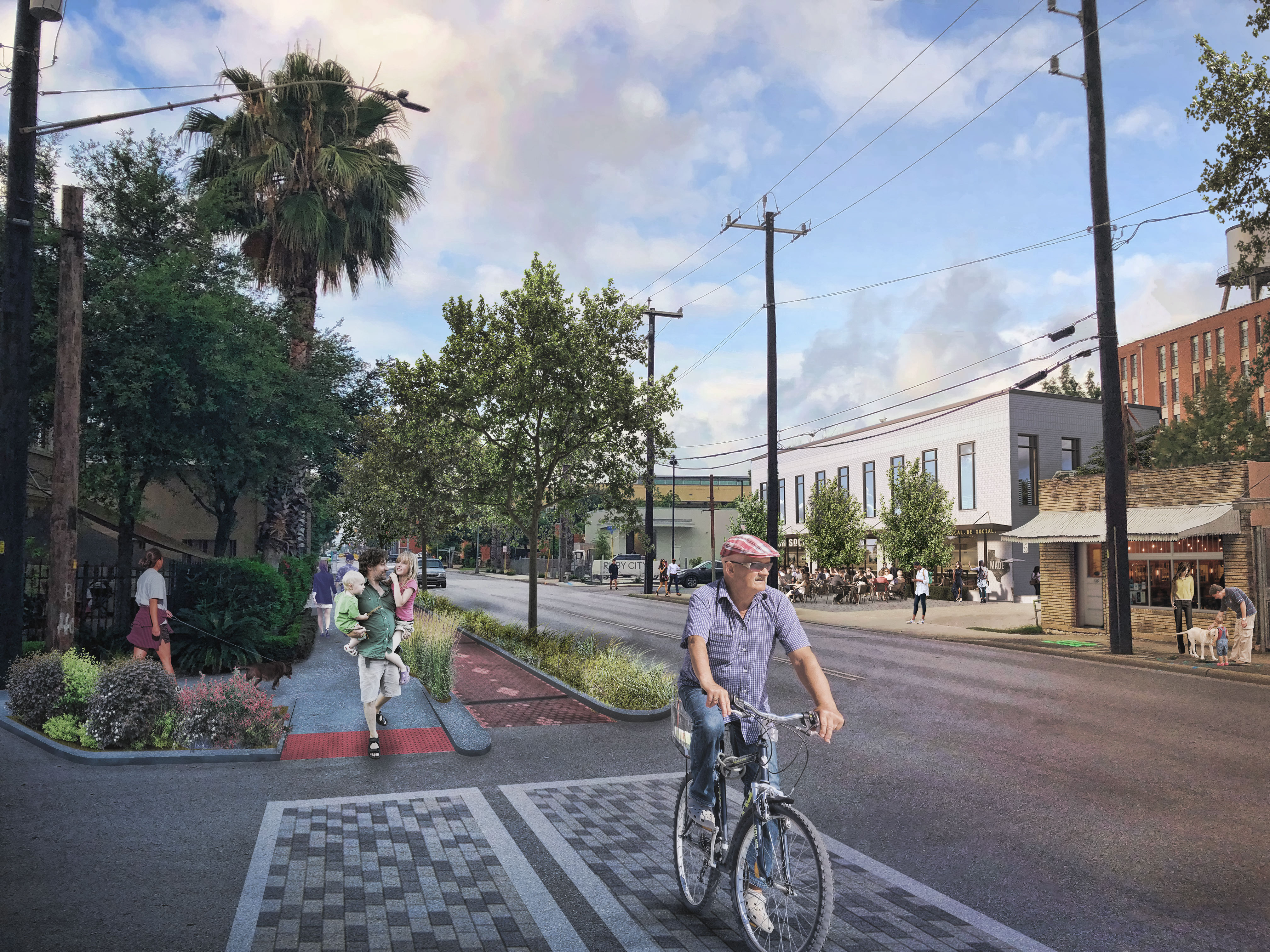
Additionally, the majority of the Downtown Area Regional Center has above ground utilities that detract from visual aesthetics and create significant barriers in the pedestrian infrastructure. In many cases, utility poles are in the center of sidewalks or on the edge of already narrow sidewalks. Though costly, above ground utilities should be consolidated and relocated to alleyways or buried to create the safest and most pleasing pedestrian environment possible.
Recommendation #4:
Promote stronger sense of community within all areas of the Downtown Area Regional Center with new and enhanced community gathering spaces.Like many Downtowns around the region and across the country, community gathering spaces were an important part of the area’s original design and layout. As the Downtown has grown and new development has occurred, community gathering spaces have not been integrated into the urban fabric with the same emphasis and care. With that said, there are many recent successes to build on in terms of both public and private provision of community gathering spaces.
The Downtown core has a significant number of existing parks and plazas. As these important elements of quality of life infrastructure continue to age and a new generation of Downtown residents, employees and visitors uses these spaces, it will be important to maintain those spaces and make investments to ensure that they are serving the various audiences in ways that stay true to the historic character and maintain and create relevancy for existing and new users.
Although challenging to find additional space within the built environment, opportunities should be identified to create new community gathering spaces. The San Pedro Creek Culture Park and larger greenway projects will add a significant amount of community gathering space to the western half of the study area. Completion of the Hemisfair redevelopment will also result in additional community gathering space. Adaptive reuse and new construction in Downtown can provide opportunities to incorporate parks, plazas, patios and other open spaces that can be open to the public. Rooftop patios and balconies can also supplement community gathering spaces as the Downtown becomes more built out. Although streets, alleys, sidewalks, and other rights-of-way primarily serve as places for people to move through, they are also the places where we interact and conduct the business of daily life. It is where children engage with, learn from, and learn how to navigate their communities. Streetscapes should incorporate interactive elements that allow children to safely play.
Recommendation #5:
Activate alleys to improve pedestrian comfort and safety while also celebrating the unique urban form of Downtown with intimate paseos, patios and plazas.A growing trend in Downtowns of all sizes is rethinking how alleys are utilized to enhance the public realm and not serve only as utilitarian back-of-house corridors. Alleys are being programmed and improved to accommodate pedestrian traffic, outdoor seating and dining, and even new retail frontages. In Downtown San Antonio, the scale of alleys fit the overall intimacy of the urban core and are well suited to supplement the existing network of paseos, patios and plazas that speckle the Downtown core. A simple and relatively inexpensive intervention that provides a large impact is lighting and art in alleys. Murals and other 2D art using adjacent building exteriors can be supplemented with 3D art and lighting suspended above alleyways. In many communities, these relatively low-cost improvements have become popular attractions for residents and visitors and help to make alleys safer and more inviting places.
However, many alleys in Downtown are still relied upon to provide service access, trash and recycling removal and more. Strategies should be developed to limit these needs to certain times of the day and week to create opportunities for using alley spaces for seating and other active uses.
Recommendation #6:
Construct drainage improvements and integrate stormwater management features to improve water quality and reduce flood risk in Downtown.The Downtown Area Regional Center is the most built out of any of the 13 regional centers identified within the SA Tomorrow Comprehensive Plan. With that said, the Downtown core and surrounding neighborhoods and districts are enjoying a renaissance and the rising value of Downtown real estate is resulting in adaptive reuse, infill development, and redevelopment at a variety of scales. As these new investments are made in the Downtown Area Regional Center, it will be important to better integrate stormwater management and other Low Impact Development techniques in both public and private projects.
While many of Downtown’s rights-of-way are constrained, there are still opportunities along certain streets, alleys, and at some intersections to repurpose portions of the right-of-way to integrate stormwater planters, bioswales and other green infrastructure techniques. These improvements can assist with stormwater management, improve water quality and reduce the risk of flooding; important concerns given the influence of the San Antonio River and San Pedro Creek in defining this area. The improvements can also help to mitigate the heat island effect and create a more comfortable and inviting pedestrian experience.
The SA Tomorrow Comprehensive Plan and Sustainability Plan provide guidance and encouragement for Low Impact Development (LID). The Downtown Area Regional Center is a unique opportunity where LID techniques should be highly encouraged. The cost and scale of development and potential profit associated with the final projects can help to justify investing in LID techniques that may have a higher upfront cost. In addition, the Downtown Area Regional Center is the most urban place in all of San Antonio. As such, more traditional techniques like detention ponds and basins are not feasible. LID techniques may make the development of certain sites more feasible and/or increase the yield of the development while contributing to sustainability and resiliency.
Recommendation #7:
Offer more convenient choices to residents who want healthy food.Parks, Trails and Open Space
Parks, trails, and open spaces are fundamental building blocks to the quality of life in Downtown. They serve multiple purposes simultaneously for social gathering, exercise, leisure, education, flood risk mitigation, clean air and water, civic engagement, and more. Their importance increases with growth in the built environment and the resident and workforce populations. In Downtown, parks, trails, and open space improvements should primarily improve access to and experience with water, create urban plazas in high growth areas, and incrementally improve existing parks and open spaces where needed. Traditional parks and plazas should be improved with amenities like Wi-Fi, shade, and programming to better serve new and existing residents. These should be supplemented with creative delivery of parks, trails and open space in public rights-of-way and as part of private development projects.
Arts and Cultural Amenities
Arts and Cultural Assets and Amenities are critical aspects of Downtown’s historic identity and sense of place, as well as important economic generators. Art and culture in Downtown takes many forms, from historic landmarks and historic districts to world class visual and performing arts, and from culinary experiences and a variety of museums to live music, festivals and more. Downtown is also home to Texas’s only independent college of art, the Southwest School of Art. These existing arts and cultural assets should be cultivated and serve as anchors, inspiration, and sources of energy for the continuing celebration and evolution of culture in Downtown.
Community Amenities
Community amenities such as schools, universities, libraries, and community centers are important places for social gathering, learning, and civic engagement. The work of building and maintaining community often occurs in these places. As Downtown’s population grows, there will be a need to enhance the capacity and offerings of community amenities that already exist. In addition, there will be a growing need to provide additional community amenities in the southern reaches of the Downtown Area Regional Center, as well as along the west and east edges of the planning area.
Character Defining Features
The Downtown Area Regional Center has no shortage of character defining features and they take a variety of forms. As additional development occurs within and near Downtown, it will be important that urban design and architecture are used effectively to showcase and enhance character defining features rather than compete with or detract from these important assets. While many more exist at a variety of scales, major character defining features identified throughout the planning process include:
- Alamo Plaza
- Columbus Park
- Confluence
- Eagleland
- Hays Street Bridge
- Hemisfair
- Main Plaza
- Market Square
- Mission Concepción
- Missions National Historical Park
- River Bend
- the River Walk
- St. Paul Square
- UTSA Downtown Campus
- Zona Cultural
Green Infrastructure and Low Impact Development
As the Downtown Area Regional Center accommodates even more people and development, the importance of pervious surfaces and green infrastructure increases. Streets, sidewalks and pathways represent an opportunity to use space for more than just transportation and recreation. They are places that can accommodate trees, landscaped areas to soak rainwater into the ground, and stormwater detention basins that include plants and potentially art.
Green infrastructure and Low Impact Development should be incorporated into the Downtown’s urban landscape at multiple scales, including individual site developments, along multiple street segments as part of street reconstructions, or through coordinated investments throughout a new development. Examples of green infrastructure and low impact design tools that may be used in Downtown Area include those listed below.
The NACTO Urban Street Stormwater Guide provides guidance and examples of green infrastructure incorporated into streets.
- Alternative street designs
- Bioretention cells
- Bioretention curb extensions and sidewalk planters
- Bioswales and vegetated swales
- Grassed infiltration areas
- Interrupted runoff flow paths
- Permeable pavement
- Rain gardens
- Sidewalk trees and tree boxe
- Street trees
- Water quality swales